Hoellensteinbach headwater catchment
Location
- Bavarian Forest, Bavaria, Germany.
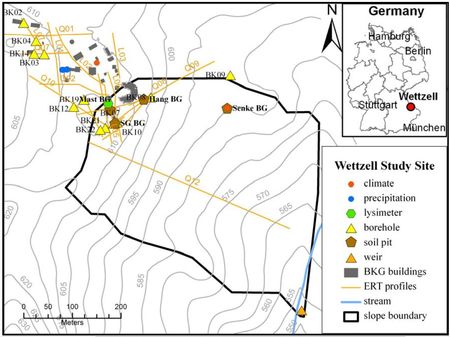
- Approx.: Latitude 49°08'40" North, _ongitude 12°52'40" East
- Altitude: 550 - 620 m above sea level
Catchment size
- Size: 0.5 km²
Climate
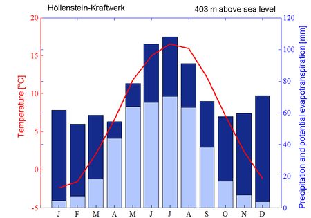
- Temperate climate
- Transition zone between oceanic and continental climate
- Mean annual precipitation: 995 mm
- Mean annual temperature: 7° C
- Mean annual potential evapotranspiration: 557 mm (Thornthwaite equation)
Geology
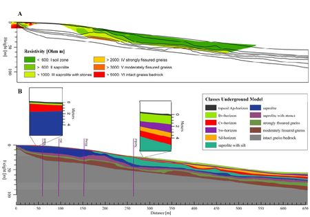
- Basement: cordierite-sillimanite gneiss of the moldanubican zone of the variscan orogenesis
- Saprolite: loosened crystalline bedrock, fractured and fissured rock, autochthonously weathered grus
- Periglacial slope deposits
- Soils: predominantly Cambisols with an estimated depth of 1.25 m, whereby Stagnosols can be also found.
Topography
- Altitude: 554 - 617 m above sea level
- Heigth difference: 63 m
- Located on a mountain ridge, which divides the watershed of the river Regen into the tributaries Weißer Regen and Schwarzer Regen
Vegetation/Land use
- Predominantly grassland and forestry
Context of investigation
- HYGRA: The effect of water storage variations on in-situ gravity measurements and their use : Measurements of the earth’s gravity are being influenced by the hydrological cycle. From a hydrological perspective, the estimation of water storage and its spatio-temporal changes is essential for setting up water balances and for effective water use and management. However, direct measurements of local water storage changes are still a challenging task while time-variable gravity observations are a promising tool as an integrative measure of total water storage changes. From a geodetic perspective, the hydrological gravity effect is an interfering signal, which imposes noise on gravimetric measurements and thus has to be eliminated from the gravity records.
Measurements/Equipment
- Superconducting gravimeters
- Climate station
- Snow monitoring system (Snow pillow, Snow height)
- Lysimeter
- TDR soil moisture clusters
- Tensiometers
- Permanent geolectrical profile
- Groundwater observation wells
- Sharp-crested 90-degree V-notch weir
- ...
Links to project webpages
- HYGRA: The effect of water storage variations on in-situ gravity measurements and their use for hydrology
- Geodetic Observatory Wettzell
References
Creutzfeldt, B., Heinrich,I., Merz, B. (2015), Total water storage dynamics derived from tree-ring records and terrestrial gravity observations, Journal of Hydrology, DOI: 10.1016/j.jhydrol.2015.04.006. Creutzfeldt, B., P. A. Troch, P. A. Ferré, A. Güntner, T. Graeff, and B. Merz (2012), Storage-discharge relationships at different catchment scales based on local high-precision gravimetry, HydrologicaL Processes, 28(3), 1465-1475, DOI: 10.1002/hyp.9689.
Creutzfeldt, B., P. A. Ferré, P. A. Troch, B. Merz, H. Wziontek, and A. Güntner (2012), Total water storage dynamics in response to climate variability and extremes - Inference from long-term terrestrial gravity measurement, Journal of Geophysical Research, 117, D08112, DOI: 10.1029/2011JD01647.
Creutzfeldt, B., Güntner, A., Vorogushyn, S., and Merz, B., (2010), The benefits of gravimeter observations for modelling water storage changes at the field scale, Hydrol. Earth Syst. Sci., 14, 1715-1730, doi:10.5194/hess-14-1715-2010
Creutzfeldt, B., Güntner, A., Wziontek, H., and Merz, B., (2010), Reducing local hydrology from high precision gravity measurements: a lysimeter-based approach, Geophysical Journal International, in press, doi:10.1111/j.1365-246X.2010.04742.x.
Creutzfeldt, B., A. Güntner, H. Thoss, B. Merz, and H. Wziontek (2010), Measuring the effect of local water storage changes on in situ gravity observations: Case study of the Geodetic Observatory Wettzell, Germany, Water Resour. Res., 46, W08531, doi:10.1029/2009WR008359.
Creutzfeldt, B., A. Güntner, T. Klugel, and H. Wziontek, (2008), Simulating the influence of water storage changes on the superconducting gravimeter of the Geodetic Observatory Wettzell, Germany: Geophysics, 73, WA95-WA104.
Creutzfeldt, B. (2010), The effect of water storages on temporal gravity measurements and the benefits for hydrology, University Potsdam, Potsdam, Germany.
Grams, E. (2010), Quantifizierung der Bodenwasserbilanz und sie kontrollierender Parameter entlang eines Hangabschnitts im Bayerischen Wald, Freie Universität Berlin, Berlin.
Heim, A. (2010), Modelling the water dynamics at a hillsope in the Bavarian Forest, Germany, 1-75 pp, University of Potsdam, Potsdam, Germany.
Müller, P. (2010), Quantifizierung des Einflusses der Makroporeninfiltration auf den Bodenwasserfluss verschiedener Standorte im Bayerischen Wald, 1-75 pp, Technische Universität Dresden, Dresden, Germany.
Raum, K. D. (2002), Markierungstechnische bruchtektonisch-gefügekundliche und fotogeologische Untersuchungen zur Ermittlung der Grundwasserfließverhältnisse in der Verwitterungszone kristalliner Gesteine in Quellgebieten des Oberpfälzer/Bayerischen Waldes (Ost-Bayern/Deutschland), 1-242 pp, Friedrich-Alexander-Universität, Erlangen-Nürnberg, Germany.


