Machuqueira do Grou Experimental Plot
Location
Located in a private property near Coruche, Portugal (39°08′ 18.29′′N, 8° 19′ 57.68′′W).
Catchment size
Climate
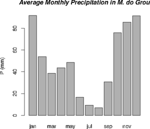
Climate is semi-arid, with strong seasonality in precipitation and temperatures.
Geology
Topography
Vegetation/Land use
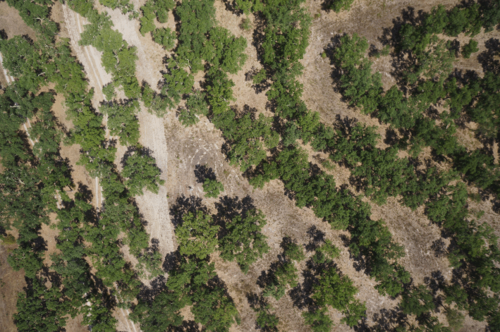
Mixed land use. Corkoaks are used for cork extraction. Understorey is used for pasture or recreational hunting.
Context of investigation
The experimental plot was initiated by the University of Lisbon, Centre of Forest Ecology. Most of the monitoring is focused on vertical carbon exchanges. As a by-product, a lot of hydrological variables have been monitored. The University of Potsdam is now investigating the understorey evapotranspiration in this stand. The objective is to understand the different stability regimes affecting the vertical transport of latent heat in different forest densities.
Measurements/Equipment
Eddy covariance tower 2 complete bowen ratio meteorological stations (soil heat flux, 4 component radiometer, wind velocity at different heights, soil moisture, psychrometry at different heights) 2 simplified micrometeorological stations (soil heat flux, 2 component radiometer, wind velocity, soil moisture) Sapflow measurements Monthly field spectrometry of leafs, grasses and shrubs
Links to project webpages
References
- Antunes, S., Carmo, M.R., Gouveia, F., Tavares, M. do C., Oliveira, N., Bessa, P. Ferreira, J.G. (2010): VALUATION OF ECOSYSTEM SERVICES AT THE LOCAL SCALE CASE STUDY – THE ROLE OF THE CORK OAK MONTADO AT HERDADE DA MACHOQUEIRA DO GROU(PORTUGAL)
- Camilo Alves, C. (2014): STUDIES ON CORK OAK DECLINE: AN INTEGRATED APPROACH, PHD thesis, Universidade de Évora, Portugal
- Correia, A.C., Costa e Silva, F., Correia, A.V., Hussain, M.Z., Rodrigues, A.D., David, J.S., Pereira, J.S. (2014): Carbon sink strength of a Mediterranean cork oak understorey: how do semi-deciduous and evergreen shrubs face summer drought? Journal of Vegetation Science, 25(2), 411–426, DOI: 10.1111/jvs.12102.
- Dubbert, M., Cuntz, M., Piayda, A.,Pereira, J.S, Maguas, C., Werner, C.: Partitioning evapotranspiration – Testing the Craig and Gordon equation against field measurements of evaporative δ 18O
- Dubbert, M. (2014): Water balance and productivity of a Mediterranean oak woodland Quantifying understory vegetation impacts by development of a stable oxygen isotope partitioning approach, Dissertation University of Bayreuth, Germany
- Jongen, M., Lecomte, X., Pereira, J.S.: The impact of changes in the amount and timing of precipitation on the herbaceous understorey of Mediterranean evergreen oak woodlands
- Pereira, J.S., Mateus, J.A., Aires, L.M., Pita, G., Pio, C., David, J.S., Andrade, V., Banza, J., David, T.S., Paco, T.A., Rodrigues, A. (2007): Net ecosystem carbon exchange in three contrasting Mediterranean ecosystems - the effect of drought. Biogeosciences 4: 791 - 802, DOI: 10.5194/bg-4-791-2007.
- Piayda, A., Dubbert, M., Rebmann, C., Kolle, O., Costa e Silva, F., Correia, A., Pereira, J.S., Werner, C., Cuntz, M. (2014): Drought impact on carbon and water cycling in a Mediterranean Quercus suber L. woodland during the extreme drought event in 2012. Biogeosciences, 11, 7159-7178, DOI: 10.5194/bg-11-7159-2014
- Shvaleva, A., Silva, F.C.E., Costa, J.M., Correia, A., Anderson, M., Lobo-do-Vale, R., Fangueiro, D., Bicho, C., Pereira, J.S., Chaves, M.M., Skiba, U., Cruz, C. (2014): Comparison of methane, nitrous oxide fluxes and CO2 respiration rates from a Mediterranean cork oak ecosystem and improved pasture. PLANT AND SOIL, 374(1-2), 883-898, DOI: 10.1007/s11104-013-1923-6.

