Sant Miquel Catchment
Location
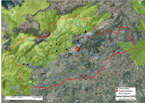
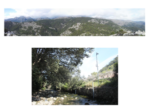
The Sant Miquel is a mesoscale mountainous catchment (145 km2) located in the Tramuntana ranges (Mallorca, Spain; 39º46’21”N, 2º56’47”E). The altitude ranges from 1000 to 1300 m.a.s.l. in the catchment headwaters where the average gradient of the channels is >20%. The lowest part of the catchment (i.e. 7%) is occupied by the most important irrigated area on the island, providing concern for the deterioration of the Sant Miquel fluvial system and the s'Albufera (1708 ha), a wetland situated at the outlet of the catchment and protected by the RAMSAR list of wetlands of international importance. Moreover, the main headwater subcatchments situated in the Tramuntana range are regulated by the presence of check-dams constructed in the 1980s, in addition to traditional terracing and transverse walls.
Climate
Mediterranean
Geology
Main Geology is Carbonates, while the soil types are Entisols in the catchment headwaters and Alfisols in the flat downstream areas
Vegetation/Land use
Main land uses are: 49% Forest, 49% agriculture and 2% urban
Context of investigation
The research focus of the Sant Miquel experimental site is to investigate changing patterns of hydrological and sediment connectivity induced by climate and land use changes in Mediterranean catchments by using a sediment budget assembled with several methods when applied to likely scenarios of global change. The objectives of the project are: 1) To develop a sediment budget as a perceptual model of hydrological and sediment connectivity by applying a multi-technique approach within the three catchments. GIS modelling, sediment-tracer techniques and continuous monitoring of water and sediment fluxes will be used to develop an understanding of catchment response. 2) To develop further the application of 137Cs fallout radionuclide to the study of soil traslocation, erosion and sediment tracing. Particular attention will be addressed to the various sources of uncertainty. Results obtained from the application of the improved techniques will be used to improve the perceptual model developed in (1). 3) To investigate contaminant transfer by water and sediment through the fluvial system and to assess the impact of such contaminants on the downstream wetlands, giving particular attention to the effects of land use. 4) To implement a Spatial Data Infrastructure (SDI) containing referenced information resulting from continuous monitoring of river fluxes (i.e. water, sediment and related contaminants from headwaters to downstream parts), implemented connectivity models with the different global change scenarios, as well as all considered data of environmental relevance from the catchment and related wetlands.
Measurements/Equipment
As the Sant Miquel catchment has been monitored following a nested approach (catchment sizes from 3 to 145 km2), different measurement techniques and equipments are being used depending on the scale.
- Historic dataset or ongoing monitoring: Land uses from 1956; check-dams projects built in the 1980s
- Type of data and variables: Discharge, dissolved and suspended sediment concentrations, precipitation, temperature, soil humidity
- Temporal resolution: Continuous (takes readings with a sample interval of 1 min and a log interval of 15 min).
Links to project webpages
Assessing hydrological and sediment connectivity in contrasting Mediterranean catchments. Impacts of global change; Funding body: Spanish Ministry of Economy and Competitiveness; Duration: 2013-2016. Principal Investigator: Dr Joan Estrany (University of the Balearic Islands).
http://medhycon.uib.cat/projects.html
References
Several publications and 2 PhD are in progress

