Na Borges River Catchment
Location
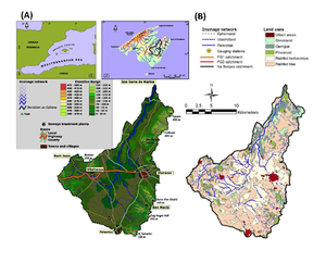
The Na Borges catchment extends over the northeastern part of the island of Mallorca (Spain; 39º 38’ 14”N 3º 09’ 11”E) where it is the second largest catchment, encompassing an area of 319 km2. It collects water from the southeastern parts of the Central Ranges and from the western slope of the Llevant Ranges. The altitude ranges from 300 to 500 m a.s.l. in the catchment headwaters, where the average slope of the channels is 8%. Downstream, the main channel has a very gentle average slope (0.3%) along its 26.8 km course to the sea.
Climate
The climate of Na Borges is classified as Mediterranean, being sub-arid over the headwaters and sub-humid in the Llevant Ranges at the outlet. The mean annual rainfall for the period 1970-2006 was 571.6 mm, with an interannual coefficient of variation of 25.9%. Autumn is the rainiest season, followed by winter, spring and summer. The topographical differences across the catchment yield a spatial coefficient of variation for annual rainfall of 13.4%, with a maximum value of 733.2 mm in the Llevant Ranges near the outlet and a minimum of 506.7 mm in Pla de Son Pou. High-intensity rainstorms with a recurrence period of 50 years may produce 150 mm in 24 hours, mainly in the mountains, as both the volume and intensity of rainfall are greatly enhanced by relief. The mean annual temperature (1970-2006) for Manacor (83 m a.s.l.) is 16.5ºC
Geology
Na Borges is a groundwater dominated river where the surface water/groundwater interaction is controlled by its hydrogeological and geomorphological characteristics and their modification by human impact. As a result, different streamflow regimes can be observed in the catchment. The headwaters of all sub-catchments and the tributaries that drain the Llevant Ranges and Marina de Petra are ephemeral due to the high degree of fracturing, fissuring and karstification, which favours infiltration and percolation through perched karstic aquifers unconnected to the channels. The lower flat areas (i.e. Pla de Son Pou) are covered by deep soils developed on the Quaternary alluvial sediments which are underlain by impermeable Lower-Middle Miocene sediments. These alluvial sediments form a shallow unconfined aquifer where groundwater flow sustains an influent discharge, but the high evaporation rates and low precipitation during the summer result in an intermittent regime. The first 5 km of Na Borges Canyon consists of impervious Lower-Middle Miocene strata that receive a perennial regime of influent flow from karstic springs draining the reefal Upper Miocene tabular platform. Downstream, these strata are progressively replaced by porous Middle-Upper Miocene sediments. Consequently, transmission losses assume increasing importance along the remaining 12 km of the Na Borges Canyon, where the intermittent flows reflect both lithological controls and the hydrometeorological conditions in this Mediterranean area
Vegetation/Land use
The catchment is predominantly rural, with a population of 47,458 inhabitants in 2001. More than 80% of the land is used for rainfed agriculture. Agriculture has modified the lower areas of the catchment, with subsurface tile drainage covering 12% of the catchment, mostly in the Pla de Son Pou. This drainage increases the flow to the Na Borges River from the shallow unconfined aquifer above the impervious Lower-Middle Miocene strata.
Context of investigation
The research focus of the Na Borges experimental site is to investigate changing patterns of hydrological and sediment connectivity induced by climate and land use changes in Mediterranean catchments by using a sediment budget assembled with several methods when applied to likely scenarios of global change. The objectives of the project are: 1) To develop a sediment budget as a perceptual model of hydrological and sediment connectivity by applying a multi-technique approach within the three catchments. GIS modelling, sediment-tracer techniques and continuous monitoring of water and sediment fluxes will be used to develop an understanding of catchment response. 2) To develop further the application of 137Cs fallout radionuclide to the study of soil traslocation, erosion and sediment tracing. Particular attention will be addressed to the various sources of uncertainty. Results obtained from the application of the improved techniques will be used to improve the perceptual model developed in (1). 3) To investigate contaminant transfer by water and sediment through the fluvial system and to assess the impact of such contaminants on the downstream wetlands, giving particular attention to the effects of land use. 4) To implement a Spatial Data Infrastructure (SDI) containing referenced information resulting from continuous monitoring of river fluxes (i.e. water, sediment and related contaminants from headwaters to downstream parts), implemented connectivity models with the different global change scenarios, as well as all considered data of environmental relevance from the catchment and related wetlands.
Measurements/Equipment
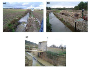
As the Na Borges catchment has been monitored following a nested approach (catchment sizes from 1 to 316 km2), different measurement techniques and equipments are being used depending on the scale.
- Historic dataset: land uses from 1956
- Type of data and variables: Discharge, dissolved and suspended sediment concentrations, precipitation, temperature, soil humidity
- Temporal resolution: Continuous (takes readings with a sample interval of 1 min and a log interval of 15 min).
Links to project webpages
Assessing hydrological and sediment connectivity in contrasting Mediterranean catchments. Impacts of global change; Funding body: Spanish Ministry of Economy and Competitiveness; Duration: 2013-2016. Principal Investigator: Dr Joan Estrany (University of the Balearic Islands).
http://medhycon.uib.cat/projects.html
References
- López-Tarazón JA, Estrany J. 2017. Exploring suspended sediment delivery dynamics of two Mediterranean nested catchments. Hydrological Processes, 31(3), 698–715 , DOI: 10.1002/hyp.11069.
- Estrany J, López-Tarazón JA, Smith H. 2015. Wildfire effects on suspended sediment delivery quantified using fallout radionuclide tracers in a Mediterranean catchment. Land Degradation & Development, DOI: 10.1002/ldr.2462.
- Estrany J, Grimalt M. 2014. Catchment controls and human disturbances on the geomorphology of small Mediterranean estuaries systems. Estuarine Coastal and Shelf Science 150B, 230-241.
- Estrany J, Garcia C, Walling DE. 2012. A suspended sediment budget for the agricultural Can Revull catchment (Mallorca, Spain). Zeitschrift für Geomorphologie 56 (3-4), 169-193.
- Estrany J, Garcia C, Walling DE, Ferrer L. 2011. Storage and fluxes of fine-grained sediment and associated contaminants in the Na Borges River (Mallorca, Spain). Catena 87(3), 291-305.
- Estrany J, Garcia C, Walling DE. 2010. An investigation of soil erosion and redistribution in a Mediterranean lowland agricultural catchment using caesium-137. International Journal of Sediment Research 25 (1), 1-16.
- Estrany J, Garcia C, Batalla RJ. 2010. Hydrological response of a small Mediterranean agricultural catchment. Journal of Hydrology 380, 180-190.
- Estrany J, Garcia C, Batalla RJ. 2009. Groundwater control on the suspended sediment load in the Na Borges River, Mallorca, Spain. Geomorphology 106 (3-4), 292-30.
- Estrany J, Garcia C, Batalla RJ. 2009. Suspended sediment transport in a small Mediterranean agricultural catchment. Earth Surface Processes and Landforms 34(7), 929-940.

