Sa Font de la Vila Catchment
Location
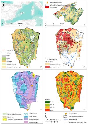
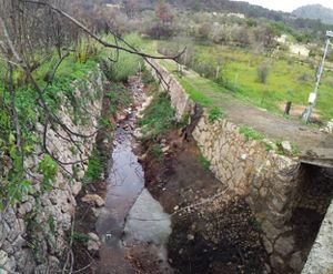
Sa Font de la Vila is a small mountainous catchment (5 km2) located in the southern part of the Tramuntana ranges (Mallorca, Spain; 39º35’10”N, 2º25’25”E). The altitude ranges from 144 m.a.s.l. at headwaters to 71 m.a.s.l. at the outlet gauging station. It is characterized by the massive presence of traditional soil conservation structures (65% of the catchment), indicative of intense -although preterit- agricultural activity. Nowadays, forests represent 71% of the catchment. Moreover, in the last 20 years, 2 severe wildfires affected the catchment. The first, in 1994, affected 45% of its surface while, the second, in 2013, affected 77% of which more than half had been burnt also in 1994.
Climate
Mediterranean
Geology
Main Geology is Carbonates, while the soil types are Entisols in the catchment headwaters and Alfisols in the flat downstream areas
Vegetation/Land use
71% forest; 29% agriculture (77% affected by wildfire in 1994 and 2013)
Context of investigation
The overall objective of this project is to combine several techniques to quantify erosion, correlating the results with the evolution of the physiological state of the vegetation, which is determined by the NDVI through camera attached to a UAV and other plant-level techniques. This project aims to investigate the role of geomorphological processes according to the condition and severity of forest fire and post-fire management performed. From here, the type of ecological patterns, states of habitat and ecological control geomorphological processes and their associated forms will arise, and vice versa. Therefore, we have selected three drainage microcatchments (ie, <2 ha) representing land use, presence of traditional soil conservation structures and dynamics of forest fires as well as post-fire management implemented. In addition, a control microcatchment unaffected by any forest fire but representative land use. All within the sa Font de la Vila catchment, subject of continuous monitoring of the flow of water and sediment post-fire.
Measurements/Equipment
As the Sa Font de la Vila catchment has been monitored following a nested approach (catchment sizes from 1 to 5 km2), different measurement techniques and equipments are being used depending on the scale.
- Historic dataset or ongoing monitoring: Land uses from 1956
- Type of data and variables: Discharge, dissolved and suspended sediment concentrations, precipitation, temperature, soil humidity
- Temporal resolution: Continuous (takes readings with a sample interval of 1 min and a log interval of 15 min).
Links to project webpages
- Research contract with the Balearic government; Duration: 2013-2015; Principal Investigator: Dr Joan Estrany (University of the Balearic Islands)
http://medhycon.uib.cat/projects.html
References
- García-Comendador, J., Fortesa, J., Calsamiglia, A., Calvo-Cases, A., Estrany, J., 2017. Post-fire hydrological response and suspended sediment transport of a terraced Mediterranean catchment. Earth Surface Processes and Landforms, DOI: 10.1002/esp.4181.

