Difference between revisions of "Discharge - ADCP (SonTek RiverSurveyor)"
Jump to navigation
Jump to search
| (3 intermediate revisions by the same user not shown) | |||
| Line 1: | Line 1: | ||
{| align="right" | {| align="right" | ||
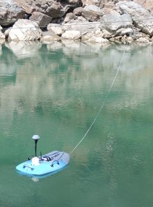
| − | |[[Image: | + | |[[Image:riv_surv_calm.JPG|right|220px|RiverSurveyor]] |
|} | |} | ||
==Parameter to be measured:== | ==Parameter to be measured:== | ||
Discharge, flow velocity, depth | Discharge, flow velocity, depth | ||
| − | + | {| align="right" | |
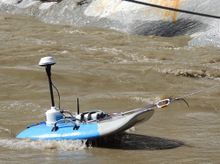
| + | |[[Image:riv_surv_marginal.JPG|right|220px|RiverSurveyor]] | ||
| + | |} | ||
==Method:== | ==Method:== | ||
Acoustic Doppler Current Profiling | Acoustic Doppler Current Profiling | ||
| Line 22: | Line 24: | ||
* measurement continues even when connection is lost | * measurement continues even when connection is lost | ||
* configurable options (communication: BT/radio, GPS: GPS/GNSS, platform: low /high velocity/remote controled) | * configurable options (communication: BT/radio, GPS: GPS/GNSS, platform: low /high velocity/remote controled) | ||
| + | |||
| + | {| align="right" | ||
| + | |[[Image:ADCP.png|right|400px|flow velocities]] | ||
| + | |} | ||
==Disadvantages:== | ==Disadvantages:== | ||
| Line 30: | Line 36: | ||
* transversal speed must be lower than flow velocity | * transversal speed must be lower than flow velocity | ||
* deeply incised riverbeds and vegetation may strongly impair GPS reception | * deeply incised riverbeds and vegetation may strongly impair GPS reception | ||
| − | * The product basic GPS-setting is advertised as "dGPS", but is merely ordinary SBAS-corrected GPS. True dGPS-solutions (base - rover) do exist, but post processing is not supported. Other GNSS-receivers may be customized. | + | * The product basic GPS-setting is advertised as "dGPS", but is merely ordinary SBAS-corrected GPS. True dGPS-solutions (base - rover) do exist, but post processing is not supported. Other GNSS-receivers may be customized with extra hardware. |
* Stratification of temperature and salinity affects the depth measurement. This can be corrected for when a CastAway CTS sensor is used. Import of data otherwise acquired is not supported. | * Stratification of temperature and salinity affects the depth measurement. This can be corrected for when a CastAway CTS sensor is used. Import of data otherwise acquired is not supported. | ||
| + | * The built-in temperature sensor shows strong thermal inertia, ie reacts slowly. In our test, an initial temperature difference of only 4 K (10°C to 6°C) took ~1 hour to equilibrate. The endpoint temperature was still 2 K above conventional measurements. | ||
| + | * When the sensor is not properly connected to the PCA, the latter appears fully operational, but does not connect via radio. | ||
==Problems/Questions:== | ==Problems/Questions:== | ||
Revision as of 14:18, 5 January 2016
Parameter to be measured:
Discharge, flow velocity, depth
Method:
Acoustic Doppler Current Profiling
Equipment:
- sensor (M9)
- processing unit (data processing, storage, GPS receiver, communication)
- GPS antenna
- platform (raft)
Advantages:
- high resolution velocity profile of river transect (up to 128 cells)
- dual frequency sensor covers wide range of depths (0.3 - 40 m)
- position can be estimated via both bottom tracking and GPS
- intuitive software for both PC and Windows Mobile
- measurement continues even when connection is lost
- configurable options (communication: BT/radio, GPS: GPS/GNSS, platform: low /high velocity/remote controled)
Disadvantages:
- platform is quite bulky
- price
What to watch out for:
- transversal speed must be lower than flow velocity
- deeply incised riverbeds and vegetation may strongly impair GPS reception
- The product basic GPS-setting is advertised as "dGPS", but is merely ordinary SBAS-corrected GPS. True dGPS-solutions (base - rover) do exist, but post processing is not supported. Other GNSS-receivers may be customized with extra hardware.
- Stratification of temperature and salinity affects the depth measurement. This can be corrected for when a CastAway CTS sensor is used. Import of data otherwise acquired is not supported.
- The built-in temperature sensor shows strong thermal inertia, ie reacts slowly. In our test, an initial temperature difference of only 4 K (10°C to 6°C) took ~1 hour to equilibrate. The endpoint temperature was still 2 K above conventional measurements.
- When the sensor is not properly connected to the PCA, the latter appears fully operational, but does not connect via radio.
Problems/Questions:
- How does sediment concentration affect the measurements?
Price:
35000 € with basic GPS option and Hydroboard (2013, Germany)
Links
Projects that used the above equipment:
Other related web sites:


