Difference between revisions of "HOAL Petzenkirchen"
| (26 intermediate revisions by 2 users not shown) | |||
| Line 1: | Line 1: | ||
| − | + | [[File:HOAL.png|thumb|right|Map of the catchment area]] | |
| − | + | ||
| + | The Hydrological Open Air Laboratory (HOAL) Petzenkirchen | ||
== Location == | == Location == | ||
| − | The catchment is situated in Petzenkirchen, in the western part of Lower Austria (15° 9’ E | + | The catchment is situated in Petzenkirchen, in the western part of Lower Austria (48° 9’ N, 15° 9’ E). |
== Catchment size == | == Catchment size == | ||
| − | The catchment area is | + | The catchment area is 66 ha. |
== Climate == | == Climate == | ||
| − | The climate can be characterised as humid with a mean annual temperature of 9. | + | The climate can be characterised as humid with a mean annual temperature of 9.5 °C and a mean annual precipitation of 823 mm/yr from 1990 to 2014. Precipitation tends to be higher in summer than in winter. Crop evapotranspiration (ETc) estimated by the FAO (1998) method using local climate data and crop growth information for this period was 471mm/yr. Annual evaporation estimated by the water balance ranged from 435 to 841 with a mean of 628 mm/yr (1990-2014). The natural surface water outlet of the catchment is known as the Seitengraben stream. Mean annual flow from the catchment in this stream is 4.1 l/s (or 195 mm/yr) (1990-2014). Mean flows tend to peak in the spring. The largest flood events on record occurred in 1949 and 2002 with estimated peak discharges of 2.8 and 2.0 m³/s, respectively. The highest discharge in recent times occurred in summer 2013 with 0.66 m³/s. |
== Geology == | == Geology == | ||
| − | + | The subsurface consists of Tertiary sediments of the Molasse zone and fractured siltstone. The dominant soil types are Cambisols and Planosols with medium to poor infiltration capacities. Gleysols occur close to the stream. | |
== Topography == | == Topography == | ||
| Line 21: | Line 22: | ||
== Context of investigation == | == Context of investigation == | ||
| − | The purpose of the HOAL project is to advance the understanding of water related flow and transport processes involving sediments, nutrients and microbes in small catchments. The HOAL catchment is ideally suited for this purpose, because it features a range of different runoff generation processes (surface runoff, springs, tile drains, wetlands), the nutrients inputs are known and it is convenient from a logistic point of view as all instruments can be connected to the power grid and a high speed Local Area Network (glassfibre). A number of innovative measurement techniques are being tested or will be tested including video cameras, distributed temperature sensing, soil moisture clusters, genetic markers as well as a range of isotopic techniques. The HOAL is operated jointly by the Vienna University of Technology and the Federal Agency for Water Management and takes advantage of | + | The purpose of the HOAL project is to advance the understanding of water related flow and transport processes involving sediments, nutrients and microbes in small catchments. The HOAL catchment is ideally suited for this purpose, because it features a range of different runoff generation processes (surface runoff, springs, tile drains, wetlands), the nutrients inputs are known and it is convenient from a logistic point of view as all instruments can be connected to the power grid and a high speed Local Area Network (glassfibre). A number of innovative measurement techniques are being tested or will be tested including video cameras, distributed temperature sensing, soil moisture clusters, genetic markers as well as a range of isotopic techniques. The HOAL is operated jointly by the Vienna University of Technology and the Federal Agency for Water Management and takes advantage of the "Vienna Doctoral Programme on Water Resource Systems" funded by the Austrian Science Foundation. |
== Measurements/Equipment == | == Measurements/Equipment == | ||
| + | [http://hoal.hydrology.at/fileadmin/images/hoal_map1500.jpg See the basic instrumentation of the catchment here.] | ||
| + | |||
| + | The basic infrastructure and monitoring in the HOAL consists of | ||
| + | |||
| + | - Atmospheric processes: four raingauges are installed to monitor spatial rainfall patterns. Three of the raingauges are distributed within the catchment and one is located close to its boundary. | ||
| + | |||
| + | - Atmospheric and soil processes: Monitoring at the weather station located approximately in the centre of gravity of the catchment includes air temperature, air humidity, wind speed and direction (all at three heights), incoming and outgoing solar and long wave radiation, wind load on the construction, rain drop size distribution, snow depths, soil heat flux and soil temperatures at different depths. | ||
| + | |||
| + | - Surface water: A total of 12 flumes were installed within the catchment to monitor discharge at 1 minute resolution from the inlet piped stream, tile drains, erosion gullies, springs and tributaries from wetlands. These flumes are the backbone of the HOAL. All flumes were calibrated in the Hydraulic Laboratory of the TU Wien to obtain a reliable stage-discharge relationship. | ||
| + | |||
| + | - Surface water: At the catchment outlet, the existing H-flume (dating from 1945 with a number of changes since) was upgraded in 2009. The maximum discharge capacity was increased and a number of additional sensors were installed including water temperature, electrical conductivity, turbidity (two probes from different makes), chloride, pH, nitrate. Grab samples are taken weekly for a range of chemical analyses including suspended solids and various compounds of nutrients. Additionally, autosamplers take water samples during events. A video camera was installed to monitor the water level in the flume and the functioning of the instruments. | ||
| + | - Groundwater: 23 piezometers were installed within the catchment where groundwater level and water temperature are monitored. Most of the piezometers are located along transects perpendicular to the stream to help understand stream-aquifer interactions. Two additional air pressure sensors were needed to correct the readings of the pressure transducers for the air pressure fluctuations. | ||
== Links to project webpages == | == Links to project webpages == | ||
| − | *[http://www. | + | *[http://hoal.hydrology.at HOAL Project web page] |
| − | *[http://www. | + | *[http://hoal.hydrology.at/fileadmin/downloads/hoal_brochure.pdf HOAL Brochure] |
| + | *[http://www.waterresources.at/index.php?id=123 Vienna Doctoral Programme on Water Resource Systems] | ||
| + | *[http://www.hydrologie.at Institute of Hydraulic Engineering, TU Wien] | ||
| + | *[http://www.baw.at/wasser-boden-ikt.html Federal Agency for Water Management, Austria] | ||
| + | *[https://www.enoha.eu/ European Network of Hydrological Observatories] | ||
== References == | == References == | ||
| − | * | + | * Blöschl, G., Blaschke, A. P., Broer, M., Bucher, C., Carr, G., Chen, X., Eder, A., Exner-Kittridge, M., Farnleitner, A., Flores-Orozco, A., Haas, P., Hogan, P., Kazemi Amiri, A., Oismüller, M., Parajka, J., Silasari, R., Stadler, P., Strauß, P., Vreugdenhil, M., Wagner, W., and Zessner, M. (2015). [http://www.hydrol-earth-syst-sci-discuss.net/12/6683/2015/hessd-12-6683-2015.html The Hydrological Open Air Laboratory (HOAL) in Petzenkirchen: a hypotheses driven observatory. Hydrology and Earth Systems Science] |
| − | * | + | *Blöschl, G., Carr, G., Bucher, C., Farnleitner, A. H., Rechberger, H., Wagner, W. and Zessner, M. (2012). [http://www.hydrol-earth-syst-sci.net/16/457/2012/hess-16-457-2012.pdf Promoting interdisciplinary education – the Vienna Doctoral Programme on Water Resource Systems. Hydrology and Earth Systems Science, Special Issue on: Hydrology Education in a Changing World, 16, 457-472.] |
| − | * | + | *Eder, A., Exner-Kittridge, M., Strauss, P., Blöschl, G. (2014). [http://www.hydrol-earth-syst-sci.net/18/1043/2014/hess-18-1043-2014.html Re-suspension of bed sediment in a small stream – results from two flushing experiments, Hydrol. Earth Syst. Sci., 18, 1043-1052, DOI: 10.5194/hess-18-1043-2014.] |
| − | *Strauss, P., Leone, A., Ripa, M.N., Turpin, N., Lescot, J.-M., Laplana R. (2007) | + | *Eder, A., Strauss, P., Krueger, T., Quinton, J.N. (2010). Comparative calculation of suspended sediment loads with respect to hysteresis effects (in the Petzenkirchen catchment, Austria). JOURNAL OF HYDROLOGY, 389(1-2), 168-176, DOI: 10.1016/j.jhydrol.2010.05.043. |
| + | *Exner-Kittridge, M., Strauss, P., Blöschl, G., Eder, A., Saracevic, E. and Zessner, M. (2016). [http://www.sciencedirect.com/science/article/pii/S0048969715309670 The seasonal dynamics of the stream sources and input flow paths of water and nitrogen of an Austrian headwater agricultural catchment. Science of The Total Environment, 542, Part A, 935-945, doi:10.1016/j.scitotenv.2015.10.151] | ||
| + | *Exner-Kittridge, M., Salinas, J. L., and Zessner, M. (2014). [https://www.researchgate.net/publication/268212068_An_evaluation_of_analytical_stream_to_groundwater_exchange_models_A_comparison_of_gross_exchanges_based_on_different_spatial_flow_distribution_assumptions An evaluation of analytical stream to groundwater exchange models: a comparison of gross exchanges based on different spatial flow distribution assumptions. Hydrology and Earth System Sciences, 18, 2715-2734. doi: 10.5194/hess-18-2715-2014] | ||
| + | *Exner-Kittridge, M., Niederreiter, R., Eder, A. and Zessner,M. (2013). [http://www.iwaponline.com/wst/06705/1026/067051026.pdf A simple and flexible field tested device for housing water monitoring sensors at point discharges. Water Science and Technology, 67 (5), 1026-1033.] | ||
| + | *Franz, T. E., Wahbi, A., Vreugdenhil, M., Weltin, G., Heng, L., Oismueller, M., Strauss, P., Dercon, G., Desilets, D. (2016). [https://www.hindawi.com/journals/aess/2016/4323742/ Using Cosmic-Ray Neutron Probes to Monitor Landscape Scale Soil Water Content in Mixed Land Use Agricultural Systems, Appl. and Environ. Soil Science, 2016, 1–11. dx.doi.org/10.1155/2016/4323742] | ||
| + | *Hösl, R., Strauss, P., Glade, T. (2012). [http://www.baw.at/images/pdf/ikt/publikationen/V_447.pdf Man-made linear flow paths at catchment scale: Identification, factors and consequences for the efficiency of vegetated filter strips, Landscape and Urban Planning, 104, 245-252, doi:10.1016/j.landurbplan.2011.10.017] | ||
| + | *Kazemi Amiri, A. and Bucher, C. (2017). [https://www.researchgate.net/publication/316605787_A_procedure_for_in_situ_wind_load_reconstruction_from_structural_response_only_based_on_field_testing_data A procedure for in situ wind load reconstruction from structural response only based on field-testing data. Journal Wind Engineering and Industrial Aerodynamics, 167, 75–86] | ||
| + | *Klaghofer, E. (2004). FLOODRISK Teilprojekt „Bodenerosion (Schwebstoffquelle)“ | ||
| + | *Silasari, R., Parajka, J., Ressl, C., Strauss, P. and Blöschl, G., (2017). [http://onlinelibrary.wiley.com/wol1/doi/10.1002/hyp.11272/full Potential of time -lapse photography for identifying saturation area dynamics on agricultural hillslopes. Hydrological Processes. 2017;1-18. https://doi.org/10.1002/hyp.11272] | ||
| + | *Stadler, P., Farnleitner, A.H., Zessner, M., (2017). [https://www.ncbi.nlm.nih.gov/pubmed/27837846 Development and evaluation of a self-cleaning custom-built auto sampler controlled by a low-cost RaspberryPi microcomputer for online enzymatic activity measurements. Talanta 162, 390–397. doi:10.1016/j.talanta.2016.10.031] | ||
| + | *Stadler, P., Blöschl, G., Vogl, W., Koschelnik, J., Epp, M., Lackner, M., Oismüller, M., Kumpan, M., Nemeth, L., Strauss, P., Sommer, R., Ryzinska-Paier, G., Farnleitner, A.H., Zessner, M., (2016). [https://www.ncbi.nlm.nih.gov/pubmed/27262553 Real-time monitoring of beta-d-glucuronidase activity in sediment laden streams: A comparison of prototypes. Water Research 101, 252–261. doi:10.1016/j.watres.2016.05.072] | ||
| + | *Strauss, P., Leone, A., Ripa, M.N., Turpin, N., Lescot, J.-M., Laplana R. (2007). Using critical source areas for targeting cost-effective best management practices to mitigate phosphorus and sediment transfer at the watershed scale. SOIL USE AND MANAGEMENT, 23(1), 144-153, DOI: 10.1111/j.1475-2743.2007.00118.x. | ||
| + | |||
[[Category:Experimental Catchments]] | [[Category:Experimental Catchments]] | ||
Latest revision as of 12:29, 15 November 2017

The Hydrological Open Air Laboratory (HOAL) Petzenkirchen
Location
The catchment is situated in Petzenkirchen, in the western part of Lower Austria (48° 9’ N, 15° 9’ E).
Catchment size
The catchment area is 66 ha.
Climate
The climate can be characterised as humid with a mean annual temperature of 9.5 °C and a mean annual precipitation of 823 mm/yr from 1990 to 2014. Precipitation tends to be higher in summer than in winter. Crop evapotranspiration (ETc) estimated by the FAO (1998) method using local climate data and crop growth information for this period was 471mm/yr. Annual evaporation estimated by the water balance ranged from 435 to 841 with a mean of 628 mm/yr (1990-2014). The natural surface water outlet of the catchment is known as the Seitengraben stream. Mean annual flow from the catchment in this stream is 4.1 l/s (or 195 mm/yr) (1990-2014). Mean flows tend to peak in the spring. The largest flood events on record occurred in 1949 and 2002 with estimated peak discharges of 2.8 and 2.0 m³/s, respectively. The highest discharge in recent times occurred in summer 2013 with 0.66 m³/s.
Geology
The subsurface consists of Tertiary sediments of the Molasse zone and fractured siltstone. The dominant soil types are Cambisols and Planosols with medium to poor infiltration capacities. Gleysols occur close to the stream.
Topography
The elevation of the catchment ranges from 268 to 323 m a.s.l. with a mean slope of 8%.
Vegetation/Land use
At present, 87% of the catchment area is arable land, 5% is used as pasture, 6% is forested and 2% is paved. The crops are mainly winter wheat and maize.
Context of investigation
The purpose of the HOAL project is to advance the understanding of water related flow and transport processes involving sediments, nutrients and microbes in small catchments. The HOAL catchment is ideally suited for this purpose, because it features a range of different runoff generation processes (surface runoff, springs, tile drains, wetlands), the nutrients inputs are known and it is convenient from a logistic point of view as all instruments can be connected to the power grid and a high speed Local Area Network (glassfibre). A number of innovative measurement techniques are being tested or will be tested including video cameras, distributed temperature sensing, soil moisture clusters, genetic markers as well as a range of isotopic techniques. The HOAL is operated jointly by the Vienna University of Technology and the Federal Agency for Water Management and takes advantage of the "Vienna Doctoral Programme on Water Resource Systems" funded by the Austrian Science Foundation.
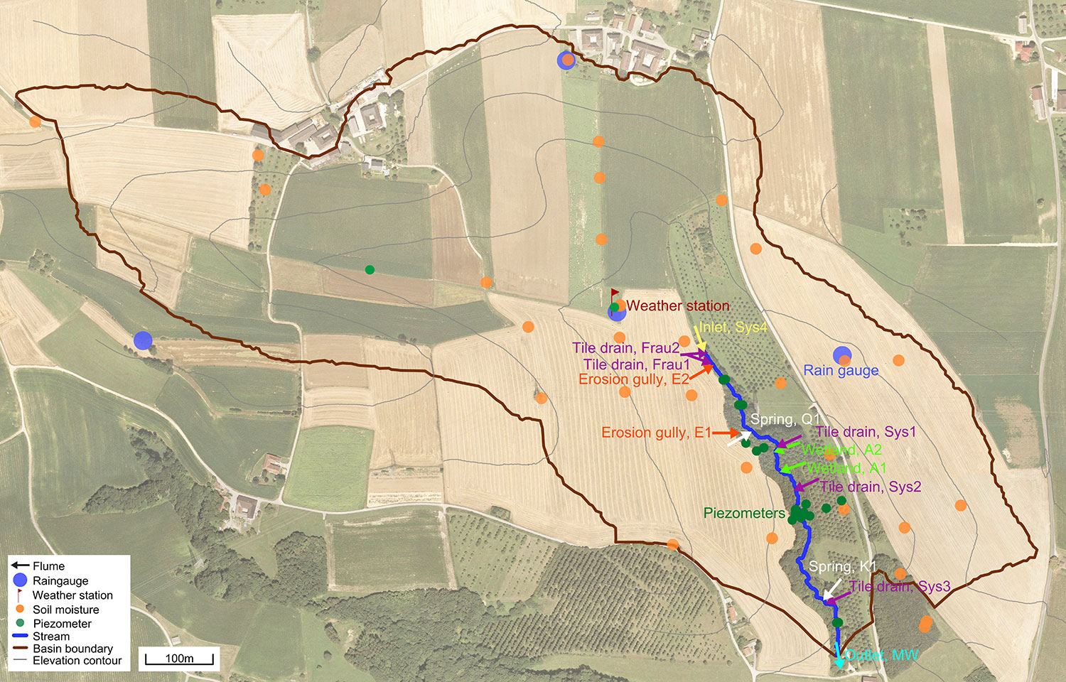
Measurements/Equipment
See the basic instrumentation of the catchment here.
The basic infrastructure and monitoring in the HOAL consists of
- Atmospheric processes: four raingauges are installed to monitor spatial rainfall patterns. Three of the raingauges are distributed within the catchment and one is located close to its boundary.
- Atmospheric and soil processes: Monitoring at the weather station located approximately in the centre of gravity of the catchment includes air temperature, air humidity, wind speed and direction (all at three heights), incoming and outgoing solar and long wave radiation, wind load on the construction, rain drop size distribution, snow depths, soil heat flux and soil temperatures at different depths.
- Surface water: A total of 12 flumes were installed within the catchment to monitor discharge at 1 minute resolution from the inlet piped stream, tile drains, erosion gullies, springs and tributaries from wetlands. These flumes are the backbone of the HOAL. All flumes were calibrated in the Hydraulic Laboratory of the TU Wien to obtain a reliable stage-discharge relationship.
- Surface water: At the catchment outlet, the existing H-flume (dating from 1945 with a number of changes since) was upgraded in 2009. The maximum discharge capacity was increased and a number of additional sensors were installed including water temperature, electrical conductivity, turbidity (two probes from different makes), chloride, pH, nitrate. Grab samples are taken weekly for a range of chemical analyses including suspended solids and various compounds of nutrients. Additionally, autosamplers take water samples during events. A video camera was installed to monitor the water level in the flume and the functioning of the instruments.
- Groundwater: 23 piezometers were installed within the catchment where groundwater level and water temperature are monitored. Most of the piezometers are located along transects perpendicular to the stream to help understand stream-aquifer interactions. Two additional air pressure sensors were needed to correct the readings of the pressure transducers for the air pressure fluctuations.
Links to project webpages
- HOAL Project web page
- HOAL Brochure
- Vienna Doctoral Programme on Water Resource Systems
- Institute of Hydraulic Engineering, TU Wien
- Federal Agency for Water Management, Austria
- European Network of Hydrological Observatories
References
- Blöschl, G., Blaschke, A. P., Broer, M., Bucher, C., Carr, G., Chen, X., Eder, A., Exner-Kittridge, M., Farnleitner, A., Flores-Orozco, A., Haas, P., Hogan, P., Kazemi Amiri, A., Oismüller, M., Parajka, J., Silasari, R., Stadler, P., Strauß, P., Vreugdenhil, M., Wagner, W., and Zessner, M. (2015). The Hydrological Open Air Laboratory (HOAL) in Petzenkirchen: a hypotheses driven observatory. Hydrology and Earth Systems Science
- Blöschl, G., Carr, G., Bucher, C., Farnleitner, A. H., Rechberger, H., Wagner, W. and Zessner, M. (2012). Promoting interdisciplinary education – the Vienna Doctoral Programme on Water Resource Systems. Hydrology and Earth Systems Science, Special Issue on: Hydrology Education in a Changing World, 16, 457-472.
- Eder, A., Exner-Kittridge, M., Strauss, P., Blöschl, G. (2014). Re-suspension of bed sediment in a small stream – results from two flushing experiments, Hydrol. Earth Syst. Sci., 18, 1043-1052, DOI: 10.5194/hess-18-1043-2014.
- Eder, A., Strauss, P., Krueger, T., Quinton, J.N. (2010). Comparative calculation of suspended sediment loads with respect to hysteresis effects (in the Petzenkirchen catchment, Austria). JOURNAL OF HYDROLOGY, 389(1-2), 168-176, DOI: 10.1016/j.jhydrol.2010.05.043.
- Exner-Kittridge, M., Strauss, P., Blöschl, G., Eder, A., Saracevic, E. and Zessner, M. (2016). The seasonal dynamics of the stream sources and input flow paths of water and nitrogen of an Austrian headwater agricultural catchment. Science of The Total Environment, 542, Part A, 935-945, doi:10.1016/j.scitotenv.2015.10.151
- Exner-Kittridge, M., Salinas, J. L., and Zessner, M. (2014). An evaluation of analytical stream to groundwater exchange models: a comparison of gross exchanges based on different spatial flow distribution assumptions. Hydrology and Earth System Sciences, 18, 2715-2734. doi: 10.5194/hess-18-2715-2014
- Exner-Kittridge, M., Niederreiter, R., Eder, A. and Zessner,M. (2013). A simple and flexible field tested device for housing water monitoring sensors at point discharges. Water Science and Technology, 67 (5), 1026-1033.
- Franz, T. E., Wahbi, A., Vreugdenhil, M., Weltin, G., Heng, L., Oismueller, M., Strauss, P., Dercon, G., Desilets, D. (2016). Using Cosmic-Ray Neutron Probes to Monitor Landscape Scale Soil Water Content in Mixed Land Use Agricultural Systems, Appl. and Environ. Soil Science, 2016, 1–11. dx.doi.org/10.1155/2016/4323742
- Hösl, R., Strauss, P., Glade, T. (2012). Man-made linear flow paths at catchment scale: Identification, factors and consequences for the efficiency of vegetated filter strips, Landscape and Urban Planning, 104, 245-252, doi:10.1016/j.landurbplan.2011.10.017
- Kazemi Amiri, A. and Bucher, C. (2017). A procedure for in situ wind load reconstruction from structural response only based on field-testing data. Journal Wind Engineering and Industrial Aerodynamics, 167, 75–86
- Klaghofer, E. (2004). FLOODRISK Teilprojekt „Bodenerosion (Schwebstoffquelle)“
- Silasari, R., Parajka, J., Ressl, C., Strauss, P. and Blöschl, G., (2017). Potential of time -lapse photography for identifying saturation area dynamics on agricultural hillslopes. Hydrological Processes. 2017;1-18. https://doi.org/10.1002/hyp.11272
- Stadler, P., Farnleitner, A.H., Zessner, M., (2017). Development and evaluation of a self-cleaning custom-built auto sampler controlled by a low-cost RaspberryPi microcomputer for online enzymatic activity measurements. Talanta 162, 390–397. doi:10.1016/j.talanta.2016.10.031
- Stadler, P., Blöschl, G., Vogl, W., Koschelnik, J., Epp, M., Lackner, M., Oismüller, M., Kumpan, M., Nemeth, L., Strauss, P., Sommer, R., Ryzinska-Paier, G., Farnleitner, A.H., Zessner, M., (2016). Real-time monitoring of beta-d-glucuronidase activity in sediment laden streams: A comparison of prototypes. Water Research 101, 252–261. doi:10.1016/j.watres.2016.05.072
- Strauss, P., Leone, A., Ripa, M.N., Turpin, N., Lescot, J.-M., Laplana R. (2007). Using critical source areas for targeting cost-effective best management practices to mitigate phosphorus and sediment transfer at the watershed scale. SOIL USE AND MANAGEMENT, 23(1), 144-153, DOI: 10.1111/j.1475-2743.2007.00118.x.