Difference between revisions of "Hydraulic Conductivity - Amoozemeter"
Jump to navigation
Jump to search
| (29 intermediate revisions by 2 users not shown) | |||
| Line 1: | Line 1: | ||
| + | [[Image:Amoozimeter.jpg|right|300px|]] | ||
| + | [[Image:Amoozi.jpg|left|300px|]] | ||
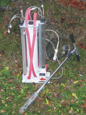
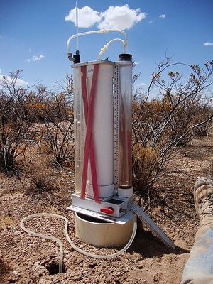
==Parameter to be measured:== | ==Parameter to be measured:== | ||
Hydraulic conductivity | Hydraulic conductivity | ||
==Method:== | ==Method:== | ||
| − | Constant head permeameter: Measures infiltration rate within an auger hole up to a depth of | + | Constant head permeameter: Measures infiltration rate within an auger hole up to a depth of 2 m and with extension set up to a depth of 4 m. A constant hydraulic head is kept in the auger hole which must be H/r >= 5 and the infiltration rate will be monitored until steady state flow is attained. Hydraulic conductivity will be calculated with the equation of Glover (Amoozegar, 1989b, 1993) |
==Equipment:== | ==Equipment:== | ||
| − | * | + | * Constant head permeameter with reservoir (with combined) Mariotte-bottle |
| + | * dissipation unit | ||
| + | * auger drill equipment | ||
| + | * measure tabe or folding meter stick | ||
| + | * datasheets, stop watch, torch for deep holes | ||
| + | * water vessels for supply | ||
| + | |||
==Advantages:== | ==Advantages:== | ||
* in-situ measurement, no analysis of disturbed soil samples in lab | * in-situ measurement, no analysis of disturbed soil samples in lab | ||
* measurement in different depths of soil profile | * measurement in different depths of soil profile | ||
| − | * easily transportable for | + | * easily transportable for monitoring at any location |
* less water consume | * less water consume | ||
| Line 18: | Line 26: | ||
* price | * price | ||
* exact geometry of auger hole as specified in the equation is not often realised | * exact geometry of auger hole as specified in the equation is not often realised | ||
| − | * in depth up to 70 cm the measurment is complicated because of | + | * in depth up to 70 cm the measurment is complicated because of controling water level |
| + | * soils with high content of gravels and boulders would be problematic because of realsing the correct geometry of the auger hole | ||
==What to watch out for:== | ==What to watch out for:== | ||
| Line 28: | Line 37: | ||
* effects of impermeable layers before stationarity is achieved | * effects of impermeable layers before stationarity is achieved | ||
* inclined, uneven surfaces | * inclined, uneven surfaces | ||
| + | * in loamy and clay soils the augering will smear up the soil pores which will lead to an underestimation of hydraulic conductivity | ||
==Problems/Questions:== | ==Problems/Questions:== | ||
| + | |||
==Links== | ==Links== | ||
| + | |||
| + | |||
Projects that used the above equipment: | Projects that used the above equipment: | ||
| + | |||
| + | * [http://www.uni-potsdam.de/echo/ The ECHO project] | ||
| + | * [http://www.grosshang.de/index.php/naturalslope.html Natural Slope] | ||
| + | * [http://brandenburg.geoecology.uni-potsdam.de/projekte/sesam/ SESAM II] | ||
Other related web sites: | Other related web sites: | ||
| + | * [http://www.youtube.com/watch?v=1pkBUl9sdOc How to Use an Amoozemeter for Soil Ksat movie] | ||
| + | * [ftp://ftp-fc.sc.egov.usda.gov/NSSC/training/TSS_Course/Participant%20Materials/04-Site_Investigations/04-amoozemeter.pdf Introduction to the Amoozemeter] | ||
==References== | ==References== | ||
| − | + | *Amoozegar, A, 1989a. A compact, constant-head permeameter for measuring saturated hydraulic conductivity of the vadose zone, Soil Sci. Soc. Am. J. 53, 1356–1361. | |
| + | *Amoozegar, A, 1989b. Comparison of the Glover solution with the simultaneous equations approach for measuring hydraulic onductivity, Soil Sci. Soc. Am. J. 53, 1362–1367. | ||
| + | *Amoozegar, A, 1993. Comments on ‘‘Methods for analyzing constanthead well permeameter data’’, Soil Sci. Soc. Am. J. 57, 559– 560. | ||
| + | *Amoozegar, A, 2005. Amoozemeter, in: Lal, R. Encyclopedia of Soil Science, Second Edition. | ||
| + | *Elrick, DE, Reynolds WD, 1992. Methods for analyzing constanthead well permeameter data, Soil Sci. Soc. Am. J. 56, 320– 323. | ||
| + | *Elrick, DE, Reynolds, WD, 1992. Methods for analyzing constanthead well permeameter data, Soil Sci. Soc. Am. J. 56, 320– 323. | ||
| + | *Elsenbeer, H, Newton, BE, Dunne T, de MoraesJM, 1999. Soil hydraulic conductivities of latosols under pasture, forest and teak in Rondonia, Brazil. Hydrol. Process. 13, 1417-1422. | ||
| + | *Sobieraj, JA, Elsenbeer, H, Coelho, RM, Newton, B, 2002, Spatial variability of soil hydraulic conductivity along a ropical rainforest catena, Geoderma 108, 79–90. | ||
| + | *Zigler, AD, Negishi, JN, Sidle, RC, Noguchi, S, Nik, AR, 2006. Impacts of logging disturbance on hillslope saturated hydraulic conductivity in a tropical forest in Peninsular Malaysia. Catena 67, 89 – 104. | ||
[[Category:Equipment]] | [[Category:Equipment]] | ||
[[Category:Hydraulic Conductivity]] | [[Category:Hydraulic Conductivity]] | ||
Latest revision as of 11:02, 5 April 2012


Parameter to be measured:
Hydraulic conductivity
Method:
Constant head permeameter: Measures infiltration rate within an auger hole up to a depth of 2 m and with extension set up to a depth of 4 m. A constant hydraulic head is kept in the auger hole which must be H/r >= 5 and the infiltration rate will be monitored until steady state flow is attained. Hydraulic conductivity will be calculated with the equation of Glover (Amoozegar, 1989b, 1993)
Equipment:
- Constant head permeameter with reservoir (with combined) Mariotte-bottle
- dissipation unit
- auger drill equipment
- measure tabe or folding meter stick
- datasheets, stop watch, torch for deep holes
- water vessels for supply
Advantages:
- in-situ measurement, no analysis of disturbed soil samples in lab
- measurement in different depths of soil profile
- easily transportable for monitoring at any location
- less water consume
Disadvantages:
- many pipes and valves - requires practice and understanding to recognise errors, set-up time
- price
- exact geometry of auger hole as specified in the equation is not often realised
- in depth up to 70 cm the measurment is complicated because of controling water level
- soils with high content of gravels and boulders would be problematic because of realsing the correct geometry of the auger hole
What to watch out for:
potential problems with
- hydrophobic soils
- heterogenous water content of soil before measurement
- strong effects from preferential flowpaths
- strong swelling/shrinking of soil
- effects of impermeable layers before stationarity is achieved
- inclined, uneven surfaces
- in loamy and clay soils the augering will smear up the soil pores which will lead to an underestimation of hydraulic conductivity
Problems/Questions:
Links
Projects that used the above equipment:
Other related web sites:
References
- Amoozegar, A, 1989a. A compact, constant-head permeameter for measuring saturated hydraulic conductivity of the vadose zone, Soil Sci. Soc. Am. J. 53, 1356–1361.
- Amoozegar, A, 1989b. Comparison of the Glover solution with the simultaneous equations approach for measuring hydraulic onductivity, Soil Sci. Soc. Am. J. 53, 1362–1367.
- Amoozegar, A, 1993. Comments on ‘‘Methods for analyzing constanthead well permeameter data’’, Soil Sci. Soc. Am. J. 57, 559– 560.
- Amoozegar, A, 2005. Amoozemeter, in: Lal, R. Encyclopedia of Soil Science, Second Edition.
- Elrick, DE, Reynolds WD, 1992. Methods for analyzing constanthead well permeameter data, Soil Sci. Soc. Am. J. 56, 320– 323.
- Elrick, DE, Reynolds, WD, 1992. Methods for analyzing constanthead well permeameter data, Soil Sci. Soc. Am. J. 56, 320– 323.
- Elsenbeer, H, Newton, BE, Dunne T, de MoraesJM, 1999. Soil hydraulic conductivities of latosols under pasture, forest and teak in Rondonia, Brazil. Hydrol. Process. 13, 1417-1422.
- Sobieraj, JA, Elsenbeer, H, Coelho, RM, Newton, B, 2002, Spatial variability of soil hydraulic conductivity along a ropical rainforest catena, Geoderma 108, 79–90.
- Zigler, AD, Negishi, JN, Sidle, RC, Noguchi, S, Nik, AR, 2006. Impacts of logging disturbance on hillslope saturated hydraulic conductivity in a tropical forest in Peninsular Malaysia. Catena 67, 89 – 104.