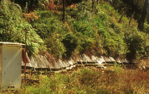
Maimai Experimental Watershed
Location
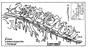
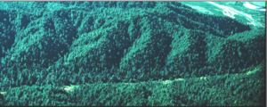
The Maimai study is made up of eight small experimental catchments in Tawhai Forest (42°05’ S, 171°48’E), 5 km north-west of Reefton, to the east of the Paparoa Range in Westland, South Island, New Zealand. The catchments are situated on south-facing slopes draining into Powerline Creek (informal name), which drains into the Mawheraiti River. All the catchments lie parallel to each other and have similar topographic characteristics. Slopes are steep (about 357, generally rectilinear to slightly concave, less than 300 m long, with local relief of 75-100m.
Catchment size
Catchment areas range from 1.63 to 8.26 ha.
Climate
- mainly superhumid, microthermal, with adequate rainfall in all seasons
- high annual rainfall (2450 mm mean annual rainfall) --> soils remain within 10% of saturation through most of the hydrologic year
- mean annual temperature is 1.1 °C, with recorded extremes of -8.5 and 33.7 °C
- mean monthly relative humidity at 9am averages 87% and ranges between 76% for December and 95% for June and July
Geology
The Maimai catchments are underlain by Old Man Gravels, conglomerates of Pliocene-Lower Pleistocene age. These are moderately weathered, tightly compacted and poorly permeable and comprise clasts of sandstone, granite and schist in a clay-sand matrix. Soils are stony silt loam podzolized yellow brown earths overlain with a 15 cm thick high porosity organic humus layer Hydraulic conductivity of the mineral soils range from 5 to 300 mm/h, the mean porosity is 45%, and soil profiles average 60 cm. The soil has a high density of preferential flow paths, including vertical cracks, live and dead root channels, and macropores in the soil profile and along the soil bedrock interface.
Vegetation/Land use
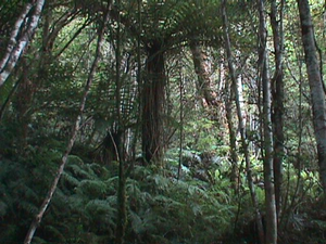
The natural vegetation in the study area is evergreen mixed beech-podocarp-hardwood forest classified. The dominant canopy species are hard beech (Nothofagus truncata) in association with the podocarps miro (Prumnopitysferruginea) and rimu (Dacrydium cupressinum). In gully heads red beech (N. Jusca) and silver beech (N. menziesii) replace the hard beech. The subcanopy is predominantly kamahi (Weinmunnia ruce-mosa). Pepperwood (Pseudowintera colorata) and Coprosma spp. are major components of the shrub tier. Ground cover is dominated by mosses and ferns (Blechnum discolor and Hymenopliyllum spp.).
Context of investigation
Maimai was established as a hydrological experimental field site in late 1974, to examine the effects of forest management on water and sediment flux. The site has been continuously monitored since.
Measurements/Equipment
- Precipitation
- Meteorology
- Runoff
- Soil Moisture
Links to project webpages
other Links
References
- Blume, T, van Meerfeld, I., 2015: From hillslope to stream: methods to investigate subsurface connectivity, WIREs Water, DOI: 10.1002/wat2.1071.
- Bonell, M., Barnes, C.J., Grant, C.R., Howard, A., Bur, J., 1998. High Rainfall, Responce-Dominated Catchments: A Comparative Sudy Of Experiments In Tropical Northeast Queensland With Temparate New Zealand, in Kendall, C., McDonnell, J.J.: Isotope Tracers in Catchment Hydrology, Elsevier, Amsterdam.
- Brammer, D., 1996. Hillslope hydrology in a small forested catchment, Maimai, New Zealand. M.S. Thesis, State University of New York College of Environmental Science and Forestry, Syracuse, 153 pp.
- Fahey, B., Jackson, R., Rowe, L.K. 1993. Hydrological effects of afforestation and pasture improvement in montane grasslands, South Island, New Zealand. ENVIRONMENTAL FOREST SCIENCE, Forestry Sciences, 54, 395-404.
- Euser, T., Winsemius, H.C., Hrachowitz, H., Fenicia, F., Uhlenbrook, S., Savenije, H.H.G. 2013. A framework to assess the realism of model structures using hydrological signatures. Hydrol. Earth Syst. Sci. 17, 1893–1912, DOI: 10.5194/hess-17-1893-2013.
- Gabrielli, C.P. McDonnell, J.J., Jarvis, W.T. 2012. The role of bedrock groundwater in rainfall-runoff response at hillslope and catchment scales. Journal of Hydrology 450–451, 117–133, DOI: 10.1016/j.jhydrol.2012.05.023.
- Gooseff, M.N., McGlynn, B.L. 2005. A stream tracer technique employing ionic tracers and specific conductance data applied to the Maimai catchment, New Zealand. Hydrological Processes 19(13), 2491–2506, DOI: 10.1002/hyp.5685.
- Graham, B.C., Woods, R.A., McDonnell, J.J. 2010. Hillslope threshold response to rainfall: (1) A field based forensic approach. Journal of Hydrology 393, 65-76, DOI: 10.1016/j.jhydrol.2009.12.015.
- Graham, C.B., McDonnell, J.J. 2010. Hillslope threshold response to rainfall: (2) Development and use of a macroscale model. Journal of Hydrology 393(1–2), 77–93, DOI: 10.1016/j.jhydrol.2010.03.008.
- McDonnell, J.J., Owens, I.F., Stewart, M.K., 1991. A case study of shallow flow paths in a steep zero-order basin. Water Resources Bulletin 27 (4), 679–685.
- McDonnell, J.J., Rowe, L.T., Stewart, M.K. 1999. A combined tracer-hydrometric approach to assess the effect of catchment scale on water flow path, source and age. Integrated Methods in Catchment Hydrology Tracer, Remote Sensing and New Hydrometric Techniques, IAHS Publ. no. 258.
- McDonnell, J.J. 1988. ‘The age, origin, and pathway of subsurface stormflow in a steep humid headwater catchment’, PhD Thesis, University of Canterbury, Christchurc.
- McDonnell, J.J., 1990. A rationale for old water discharge through macropores in a steep, humid catchment. Water Resources Research 26 (11), 2821–2832.
- McGlynn, B.L., McDonnell, J.J., Brammer, D.D., 2002. A review of the evolving perceptual model of hillslope flowpaths at the Maimai catchments, New Zealand. Journal of Hydrology 257, 1–26.
- McGlynn, B.L., McDonnell, J.J., 2003. Role of discrete landscape units in controlling catchment dissolved organic carbon dynamics. Water Resources Research. 9(4), 1090, DOI: 10.1029/2002WR001525.
- McGlynn, B.L.2002. Characterizing hillslope-riparian-stream interactions : a scaling perspective, maimai, new zealand. Dissertation, State University of New York. College of Environmental Science and Forestry, Syracuse, NY, USA.
- Mosley, M.P., 1979. Streamflow generation in a forested watershed. Water Resources Research 15, 795–806.
- Mosley, M.P., 1982. Subsurface flow velocities through selected forest soils, South Island, New Zealand. Journal of Hydrology 55, 65–92.
- Moore, T.R., 1989. Dynamics of dissolved organic carbon in forested and disturbed catchments, Westland, New Zealand: 1. Maimai. Water Resources Research, 25(6),1321–1330, DOI: 10.1029/WR025i006p01321.
- O'Loghlin, C.L., Rowe, L.K., Pearce, A.J., 1978. Sediment yields from small forested catchments North Westland - Nelson, New Zealand. Journal of Hydrology New Zealand 17(1), 1-15.
- Pearce, A.J., Rowe, L.K., 1979. Forest management effects on interception, evaporation, and water yield. Journal of Hydrology 18 (2), 73–87.
- Pearce, A.J., Stewart, M.K., Sklash, M.G., 1986. Storm runoff generation in humid headwater catchments: 1. Where does the water come from? Water Resources Research 22, 1263–1272.
- Rowe, L.K., Fahey, B. 1991. HYDROLOGY AND WATER CHEMISTRY CHANGES AFTER HARVESTING SMALL INDIGENOUS FOREST CATCHMENTS WESTLAND NEW ZEALAND. Sediment and Stream Water Quality in a Changing Environment: Trends and Explanation, IAHS Publ. no. 203.
- Rowe, L.K., Pearce, A.J., O’Loughlin, C.L., 1994. Hydrology and related changes after harvesting native forests and establishing Pinus radiata plantations Part 1. Introduction to the study. Hydrol. Process. 8, 263–279.
- Rowe, L.T., Taylor, C.H. 1994. Hydrology and related changes after harvesting native forest catchments and establishing pinus radiata plantations. Part 3. Stream temperatures. Hydrol. Process. 8(4) 299–310, DOI: 10.1002/hyp.3360080403.
- Seibert, J., McDonnell, J.J. 2015. Gauging the Ungauged Basin: Relative Value of Soft and Hard Data. Journal of Hydrologic Engineering, 20(1), A4014004, DOI: 10.1061/(ASCE)HE.1943-5584.0000861.
- Sklash, M.G., Stewart, M.K., Pearce, A.J. 1986. Storm Runoff Generation in Humid Headwater Catchments: 2. A Case Study of Hillslope and Low-Order Stream Response. Water Resources Research 22(8), 1273–1282, DOI: 10.1029/WR022i008p01273.
- Uchida, T., McDonnell, J.J., Asano, Y. 2006. Functional intercomparison of hillslopes and small catchments by examining water source, flowpath and mean residence time. Journal of Hydrology 327(3-4), 627-642, DOI: 10.1016/j.jhydrol.2006.02.037.
- Woods, R., Rowe, L. 1996. The changing spatial variability of subsurface flow across a hillside. Journal of Hydrology (New Zealand) 35 (1), 51–86.
- Woods, R., Rowe, L. 1997. Reply to ‘‘Comment on The changing spatial variability of subsurface flow across a hillside by Ross Woods and Lindsay Rowe”. Journal of Hydrology (New Zealand) 36 (1), 51–86.
