Difference between revisions of "Noordplas Polder - Netherlands"
Jump to navigation
Jump to search
| Line 40: | Line 40: | ||
== References == | == References == | ||
| − | *de Louw,P.G.B., Vandenbohede, A., Werner, A.D., Oude Essink, G.H.P. 2013.Natural saltwater upconing by preferential groundwater discharge through boils. Journal of Hydrology, 490, 74–87, DOI: 10.1016/j.jhydrol.2013.03.025. | + | *[https://publicwiki.deltares.nl/download/attachments/55640074/2013_DeLouw_SWU_boils.pdf?version=2&modificationDate=1395826907877 de Louw,P.G.B., Vandenbohede, A., Werner, A.D., Oude Essink, G.H.P. 2013.Natural saltwater upconing by preferential groundwater discharge through boils. Journal of Hydrology, 490, 74–87, DOI: 10.1016/j.jhydrol.2013.03.025.] |
*[http://www.hydrol-earth-syst-sci.net/15/2101/2011/hess-15-2101-2011.html de Louw,P.G.B., van der Velde, Y., van der Zee, S.E.A.T.M. 2011. Quantifying water and salt fluxes in a lowland polder catchment dominated by boil seepage: a probabilistic end-member mixing approach. Hydrol. Earth Syst. Sci., 15, 2101–2117, DOI: 10.5194/hess-15-2101-2011.] | *[http://www.hydrol-earth-syst-sci.net/15/2101/2011/hess-15-2101-2011.html de Louw,P.G.B., van der Velde, Y., van der Zee, S.E.A.T.M. 2011. Quantifying water and salt fluxes in a lowland polder catchment dominated by boil seepage: a probabilistic end-member mixing approach. Hydrol. Earth Syst. Sci., 15, 2101–2117, DOI: 10.5194/hess-15-2101-2011.] | ||
| − | *de Louw,P.G.B., Oude Essink, G.H.P., Stuyfzand, P.J., van der Zee, S.E.A.T.M. 2010.Upward groundwater flow in boils as the dominant mechanism of salinization in deep polders, The Netherlands. Journal of Hydrology, 394, 494–506, DOI: 10.1016/j.jhydrol.2010.10.009. | + | *[https://publicwiki.deltares.nl/download/attachments/55640074/2010_DeLouw_etal.pdf?version=1&modificationDate=1395827267185 de Louw,P.G.B., Oude Essink, G.H.P., Stuyfzand, P.J., van der Zee, S.E.A.T.M. 2010.Upward groundwater flow in boils as the dominant mechanism of salinization in deep polders, The Netherlands. Journal of Hydrology, 394, 494–506, DOI: 10.1016/j.jhydrol.2010.10.009.] |
[[Category:Experimental Catchments]] | [[Category:Experimental Catchments]] | ||
Revision as of 10:32, 16 May 2014
Location
latitude 52°04' N, longitude 04°34' E
Catchment size
37 km²
Climate
- Maritime
- long-term mean annual precipitation 916 mm
- potential evapotranspiration after Makkink 615 mm
Geology
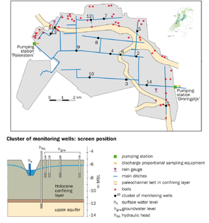
The geohydrological situation is characterized by two (semi-) confined aquifers of Pleistocene sands. The upper aquifer is covered by a 6–9 m thick, confining layer of Holocene peat, loam and clay of low permeability. At various locations, the compacted peat and overlying loam and clay deposits have been eroded by streams and tidal channels during the Holocene. The groundwater in the Pleistocene aquifers is brackish to saline and shows an increasing trend of chloride concentrations with depth.
Topography
average soil surface level is 5 m below mean sea level
Vegetation/Land use
- 86% is used for agriculture (arable farming 62%; pasture 24%)
- 14% is urban area
Context of investigation
- hydrologic processes including water quality, salinisation and water management
Measurements/Equipment
- Meteorological station dating from 1996 to the present are available
- Runoff/ Water level monitoring
- Piezometers
- Soil moisture
Links to project webpages
other Links
Deltares - Seepage through boils leads to polder salinisation
References
- de Louw,P.G.B., Vandenbohede, A., Werner, A.D., Oude Essink, G.H.P. 2013.Natural saltwater upconing by preferential groundwater discharge through boils. Journal of Hydrology, 490, 74–87, DOI: 10.1016/j.jhydrol.2013.03.025.
- de Louw,P.G.B., van der Velde, Y., van der Zee, S.E.A.T.M. 2011. Quantifying water and salt fluxes in a lowland polder catchment dominated by boil seepage: a probabilistic end-member mixing approach. Hydrol. Earth Syst. Sci., 15, 2101–2117, DOI: 10.5194/hess-15-2101-2011.
- de Louw,P.G.B., Oude Essink, G.H.P., Stuyfzand, P.J., van der Zee, S.E.A.T.M. 2010.Upward groundwater flow in boils as the dominant mechanism of salinization in deep polders, The Netherlands. Journal of Hydrology, 394, 494–506, DOI: 10.1016/j.jhydrol.2010.10.009.
