Difference between revisions of "Walnut Gulch Experimental Watershed"
Jump to navigation
Jump to search
| Line 35: | Line 35: | ||
[[Category:Experimental Catchments]] | [[Category:Experimental Catchments]] | ||
| + | *Costa, A.C., Bronstert, A., de Araújo, J.C. 2012. [http://www.hydrol-earth-syst-sci.net/16/1111/2012/hess-16-1111-2012.html A channel transmission losses model for different dryland rivers.] Hydrol. Earth Syst. Sci., 16, 1111-1135, DOI: 10.5194/hess-16-1111-2012. | ||
| + | * White, C.B., Houser, P.R., Arain, A.M., Yang, Z.L., Syed, K., Shuttleworth, W.J. 1997. [http://www.hydrol-earth-syst-sci.net/1/205/1997/hess-1-205-1997.html The aggregate description of semi-arid vegetation with precipitation-generated soil moisture heterogeneity. Hydrol.] Earth Syst. Sci., 1, 205-212, DOI: 10.5194/hess-1-205-1997. | ||
Revision as of 10:57, 15 November 2013
Location
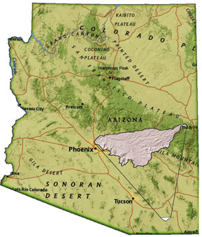
Located in SE Arizona, USA surrounding the historic city of Tombstone, the 150 km² Walnut Gulch Experimental Watershed was established in the early 1950's to study the role of watershed treatments on downstream water yield. The site was deemed typical of the black grama grass-brush dominated areas of southern New Mexico and Arizona.
Catchment size
150 km²
Climate
Semiarid
Geology
Vegetation/Land use
Black grama grass-brush dominated areas
Context of investigation
The role of watershed treatments on downstream water yield
Measurements/Equipment
- Precipitation since 1953
- Meteorology
- Runoff
- Sediment transport
- Soil Moisture
Links to project webpages
other Links
References
- Costa, A.C., Bronstert, A., de Araújo, J.C. 2012. A channel transmission losses model for different dryland rivers. Hydrol. Earth Syst. Sci., 16, 1111-1135, DOI: 10.5194/hess-16-1111-2012.
- White, C.B., Houser, P.R., Arain, A.M., Yang, Z.L., Syed, K., Shuttleworth, W.J. 1997. The aggregate description of semi-arid vegetation with precipitation-generated soil moisture heterogeneity. Hydrol. Earth Syst. Sci., 1, 205-212, DOI: 10.5194/hess-1-205-1997.

