Weißeritz catchment
Jump to navigation
Jump to search


Location
Eastern Ore Mountains, Czech Republic/Saxony Germany
Catchment size
360km² at the gauge Dresden, Wilde Weißeritz at the gauge Ammelsdorf 49 km² and at the gauge Rehefeld 16 km²
Climate
humid - temperate, annual precipitation in the upper part approximately 1,000 mm
Geology
Soils in the upper part of the catchment are dominated by Cambisoils and Podsols on periglacial covering layers. Substrate is loamy with a high content of gravel. The parent rock consists of Phylite and Gneis.
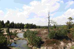
Topography
Mid moutain area, elevation 300 - 920 m a.s.l.
Vegetation/Land use
The catchment is dominated by forests (mainly spruce), arable land and pasture. In the upper part can be found raised bog, but they are mainly drained.
Context of investigation
- Identification of hydrological processes
- Flood forecasting
- climate change
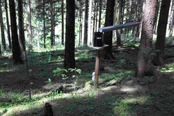
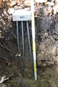
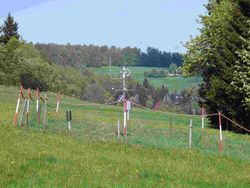
Measurements/Equipment
- gauges
- rain gauges
- soil moisture in different scales
Links to project webpages
other Links
- Wilde Weißeritz description in wikipedi
- Runoff data gauge Rehefeld
- Runoff data gauge Ammelsdorf
- Meteorological data at the station Bärenfels
References
- Burger, G; Reusser, D; Kneis, D. (2009): Early flood warnings from empirical (expanded) downscaling of the full ECMWF Ensemble Prediction System. WATER RESOURCES RESEARCH, 45, W10443
- Cunah Costa, A., Bronstert, A., Kneis, D. (2011): Probabilistic flood forecasting for a mountainous headwater catchment (49 km2) using a nonparametric stochastic dynamic approach. HYDROLOGICAL SCIENCES JOURNAL-JOURNAL DES SCIENCES HYDROLOGIQUES, accepted.
- Franke, J., Bernhöfer, C. (2009): A method for deriving a future temporal spectrum of heavy precipitation on the basis of weather patterns in low mountain ranges. Meteorol. Appl. 16: 513–522.
- Franke, J., Goldberg, V., Eichelmann, U., Freydank, E., Bernhofer, C. (2007): Statistical analysis of regional climate trends in Saxony, Germany. Clim Res 27: 145–150.
- Franke, J., Häntzschel, J., Goldberga, V., Bernhofer, C. (2008): Application of a trigonometric approach to the regionalization of precipitation for a complex small-scale terrain in a GIS environment. Meteorol. Appl. 15: 483–490.
- Heistermann, M. Kneis, D. (2011): Benchmarking quantitative precipitation estimation by conceptual rainfall‐runoff modeling.Water Resour. Res. 47: W06514, doi:10.1029/2010WR009153.
- Kneis, D., Heistermann, M. (2009): Quality assessment of radar-based precipitation estimates with the example of a small catchment. HYDROLOGIE UND WASSERBEWIRTSCHAFTUNG, 53(3), 160-171.
- Merta, M., Seidler, C., Bianchin, S., Heilmeier, H., Richter, E. (2008): Analysis of land change in eastern ore mountains reagrding both nature protection and flood prevention. Soil & Water Res., 3(1), S105–S115.
- Pöhler, H. (2006): Anpassung von WaSiM-ETH und die Erstellung und Berechnung von Landnutzungs und Klimaszenarien für die Niederschlag-Abfluss-Modellierung am Beispiel des Osterzgebirges, Freiberg, Germany, Dissertation.
- Wenzel, R. (2004):Simulation der Niederschlag-Abfluss-Verhältnisse zur Rekonstruktion von Hochwasserabflüssen in einem Kleinsteinzugsgebiet der Wilden Weißeritz, östliches Erzgebirge. FU Berlin, Germany, Master theses.
- Zehe, E., Graeff, T., Morgner, M., Bauer, A., Bronstert, A. (2010): Plot and field scale soil moisture dynamics and subsurface wetness control on runoff generation in a headwater in the Ore Mountains. HYDROLOGY AND EARTH SYSTEM SCIENCES, 14(6), 873-889.
- Zimmerman, L., Zimmerman, F. (2002): Fog deposition to Norway Spruce stands at high-elevation sites in the Eastern Erzgebirge (Germany). JOURNAL OF HYDROLOGY, 256(3-4), 166-175.