Difference between revisions of "Rio Vauz catchment"
Jump to navigation
Jump to search
| Line 1: | Line 1: | ||
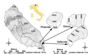
| + | [[File:Rio vauz.png|thumb|right|Map of the catchment area]] | ||
== Location == | == Location == | ||
Central-eastern Italian Alps | Central-eastern Italian Alps | ||
Revision as of 14:58, 12 November 2013
Location
Central-eastern Italian Alps
Catchment size
1.9 km², with elevation range of 1,835 – 3,152 m and an avarage slope of 34.3 °
Climate
- alpine humid climate
- mean annual rainfall of about 1220 mm, 49% of which falls as snow
- precipitation monthly distribution shows a peak in early summer and a second one during fall
- in the lower parts of the catchment the snow cover period typically lasts from November to April. Runoff is usually dominated by snowmelt in May and June but summer and early autumn floods represent an important contribution to the flow regime. The average monthly temperature in the lower Vauz varies from 5.7 °C in January to 14.1 °C in July
Geology
- consist of dolomite that supports subvertical cliffs
Vegetation/Land use
The basin is almost undisturbed by human activity: neither roads nor urban areas are present. The soil is primarily vegetated with grass (mainly of herbaceous associations), with root zone depth around 20 cm. Sparse woody vegetation (mainly larch) is distributed on a few hillslopes in the lower portion of the catchment.
Context of investigation
Measurements/Equipment
- Precipitation
- Meteorology
- Runoff
- Soil Moisture: THETA probe, TDR
- Landslides
Links to project webpages
other Links
References
- Borga, M., Dalla Fontana, G., Gregoretti, C., Marchi, L. 2002. Assessment of shallow landsliding by using a physically based model of hillslope stability. Hydrol. Process. 16(14), 2833-2851, DOI: 10.1002/hyp.1074.
- Penna, D., Borga, M., Boscolo, P., Dalla Fontana, G. 2006. DISTRIBUTION OF SOIL MOISTURE OVER DIFFERENT DEPTHS IN A SMALL ALPINE BASIN. in: Pfister, L., Hoffmann, L. 2006. Uncertainties in the ‘monitoring-conceptualisation- modelling’ sequence of catchment research. 11th Conference of the uromediterranean Network of Experimental and Representative Basins (ERB) Luxembourg, 20 – 22 September 2006. Public Research Center – Gabriel Lippmann (Luxembourg) and ERB, UNESCO/IHP (NE FRIEND Project 5).
- Penna, D., Norbiato, D., Borga, M., Dalla Fontana, G. 2007. Analisi della stabilit`a temporale dell’umidit`a del suolo in un piccolo bacino dolomitico/Temporal stability of surface soil moisture in a small alpine catchment, in: Ricerche ed esperienze di Sistemazioni Idraulico-Forestali (vol. 27, 489-502), edited by: Bischetti, G., Nuova Editoriale Bios, Cosenza, Italy.
- Penna, D., Borga, M., Norbiato, D., and Dalla Fontana, G.2009. Hillslope scale soil moisture variability in a steep alpine terrain, J. Hydrol., 364, 311–327, doi:10.1016/j.jhydrol.2008.11.009.
- Penna, D., Borga, M., Sangati, M., and Gobbi, A. 2010. Dynamics of soil moisture, subsurface flow and runoff in a small alpine basin. IAHS Publications, Red Book Series 336, ISBN 978-1-907161- 08-7, 96–102.
- Penna, D., Tromp-van Meerveld, H.J., Gobbi, A., M. Borga, M., Dalla Fontana, G. 2011. The influence of soil moisture on threshold runoff generation processes in an alpine headwater catchment. Hydrol. Earth Syst. Sci., 15, 689–702, DOI: 10.5194/hess-15-689-2011.
- Penna, D., Broca, L., Borga, M. 2013. Soil moisture temporal stability at different depths on two alpine hillslopes during wet and dry periods. J. Hydrol. 477, 55-71, DOI: 10.1016/j.jhydrol.2012.10.052.
- Penna, D. 2008. Soil moisture distribution and runoff response at the hillslope scale: experimental analysis in an alpine environment. Università degli Studi di Padova
