Difference between revisions of "Huewelerbach catchment Luxembourg"
Jump to navigation
Jump to search
| Line 41: | Line 41: | ||
== References == | == References == | ||
| − | Fenicia F., Savenije H.H.G., Matgen P., Pfister L., 2005. [http://www.hydrol-earth-syst-sci.net/10/139/2006/hess-10-139-2006.html Is the groundwater reservoir linear? Learning from data in hydrological modelling.] Hydrology and Earth System Sciences, 10, 139-151. | + | :Fenicia F., Savenije H.H.G., Matgen P., Pfister L., 2005. [http://www.hydrol-earth-syst-sci.net/10/139/2006/hess-10-139-2006.html Is the groundwater reservoir linear? Learning from data in hydrological modelling.] Hydrology and Earth System Sciences, 10, 139-151. |
| − | Gerrits A.M.J., Savenije H.H.G., Hoffmann L., Pfister L., 2007. [http://www.hydrol-earth-syst-sci.net/11/695/2007/hess-11-695-2007.html New technique to measure forest floor interception - an application in a beech forest in Luxembourg]. Hydrology and Earth System Sciences, 11, 695-701. | + | :Gerrits A.M.J., Savenije H.H.G., Hoffmann L., Pfister L., 2007. [http://www.hydrol-earth-syst-sci.net/11/695/2007/hess-11-695-2007.html New technique to measure forest floor interception - an application in a beech forest in Luxembourg]. Hydrology and Earth System Sciences, 11, 695-701. |
| − | Juilleret J., Hissler C., Heintz R., Iffly J.-F., Wrede S., Pfister L., Hoffmann L., 2009. Un exemple de cartographie pédo-géologique couplée: le bassin versant expérimental du Huewelerbach au Luxembourg. Submitted to Archives de l'Institut Grand-Ducal de Luxembourg, Section des Sciences naturelles, physiques et mathématiques. | + | :Juilleret J., Hissler C., Heintz R., Iffly J.-F., Wrede S., Pfister L., Hoffmann L., 2009. Un exemple de cartographie pédo-géologique couplée: le bassin versant expérimental du Huewelerbach au Luxembourg. Submitted to Archives de l'Institut Grand-Ducal de Luxembourg, Section des Sciences naturelles, physiques et mathématiques. |
| − | Martínez-Carreras N., Krein A., Iffly J.-F., Pfister L., Hoffmann L., Gallart F., 2007. Estimating suspended sediment loads and their uncertainty using sediment rating curves in the Attert river basin and sub-basins (Grand Duchy of Luxembourg). Proceedings of the International Conference on Off-site Impacts of Soil Erosion and Sediment Transport, Prague, Czech Republic. | + | :Martínez-Carreras N., Krein A., Iffly J.-F., Pfister L., Hoffmann L., Gallart F., 2007. Estimating suspended sediment loads and their uncertainty using sediment rating curves in the Attert river basin and sub-basins (Grand Duchy of Luxembourg). Proceedings of the International Conference on Off-site Impacts of Soil Erosion and Sediment Transport, Prague, Czech Republic. |
| − | Pfister L. et. al., 2006. Cycleau project - Final report to the National Research Fund. 133 p. | + | :Pfister L. et. al., 2006. Cycleau project - Final report to the National Research Fund. 133 p. |
Van den Bos R., Hoffmann L., Juilleret J., Matgen P., Pfister L., 2006. Regional runoff prediction through aggregation of first-order hydrological process knowledge: a case study’. Hydrological Sciences Journal, 51, 1021-1038. | Van den Bos R., Hoffmann L., Juilleret J., Matgen P., Pfister L., 2006. Regional runoff prediction through aggregation of first-order hydrological process knowledge: a case study’. Hydrological Sciences Journal, 51, 1021-1038. | ||
[[Category:Experimental Catchments]] | [[Category:Experimental Catchments]] | ||
Revision as of 11:46, 8 November 2013
Location
Upper Attert basin / Mosel basin, Luxembourg
Catchment size
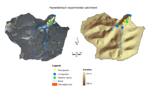
2.7 km²
Climate
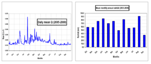
796 mm, 8.8 °C (2005 – 2008)
Geology
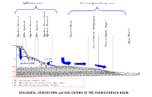
Sandstone, alternation of marls and limestones
Topography
289 m - 401 m a.s.l.
Vegetation/Land use
91.5 % forest, 7 % grassland, 1.5 % urbanised
Context of investigation
Process understanding
Measurements/Equipment
- Meteorological station
- Runoff since 2002
- Groundwater level since 2003
- Chemical analysis since2002
- Sediment
- Interception since 2003
Links to project webpages
other Links
References
- Fenicia F., Savenije H.H.G., Matgen P., Pfister L., 2005. Is the groundwater reservoir linear? Learning from data in hydrological modelling. Hydrology and Earth System Sciences, 10, 139-151.
- Gerrits A.M.J., Savenije H.H.G., Hoffmann L., Pfister L., 2007. New technique to measure forest floor interception - an application in a beech forest in Luxembourg. Hydrology and Earth System Sciences, 11, 695-701.
- Juilleret J., Hissler C., Heintz R., Iffly J.-F., Wrede S., Pfister L., Hoffmann L., 2009. Un exemple de cartographie pédo-géologique couplée: le bassin versant expérimental du Huewelerbach au Luxembourg. Submitted to Archives de l'Institut Grand-Ducal de Luxembourg, Section des Sciences naturelles, physiques et mathématiques.
- Martínez-Carreras N., Krein A., Iffly J.-F., Pfister L., Hoffmann L., Gallart F., 2007. Estimating suspended sediment loads and their uncertainty using sediment rating curves in the Attert river basin and sub-basins (Grand Duchy of Luxembourg). Proceedings of the International Conference on Off-site Impacts of Soil Erosion and Sediment Transport, Prague, Czech Republic.
- Pfister L. et. al., 2006. Cycleau project - Final report to the National Research Fund. 133 p.
Van den Bos R., Hoffmann L., Juilleret J., Matgen P., Pfister L., 2006. Regional runoff prediction through aggregation of first-order hydrological process knowledge: a case study’. Hydrological Sciences Journal, 51, 1021-1038.


