Difference between revisions of "Plynlimon experimental catchments, Wales UK"
| Line 12: | Line 12: | ||
== Topography == | == Topography == | ||
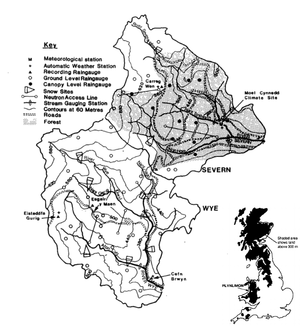
| + | The landscape of Plynlimon is dominated by rolling hills dissected by steep valleys. The altitudinal range is from 319 m ODN in the Severn and 341 m in the Wye up to 738 m. In terms of slopes, the Severn is locally steeper than the Wye catchment. Both catchments have limited development of valley flat areas associated with hort alluvial reaches. Most reaches are confined within valley side slopes. Most streams are flowing over bed rock, sometimes with a shallow covering of river sediments. The irregularities in the profiles are typical of British upland channels. The steps often coincide with resistant bands of rock Such rock controls are apparent in both catchments. Although there are slope angles greater than 25° which are local to the lower parts of the Wye catchment the vast majority of slopes in both catchments are in the range 0° to 15°. The major differences between the two catchments concern the degree to which the extensive Tertiary plateaux of Plynlimon are crossed by their tributary streams. | ||
== Vegetation/Land use == | == Vegetation/Land use == | ||
Revision as of 11:28, 25 February 2016
Location
Catchment size
Climate
Geology
Topography
The landscape of Plynlimon is dominated by rolling hills dissected by steep valleys. The altitudinal range is from 319 m ODN in the Severn and 341 m in the Wye up to 738 m. In terms of slopes, the Severn is locally steeper than the Wye catchment. Both catchments have limited development of valley flat areas associated with hort alluvial reaches. Most reaches are confined within valley side slopes. Most streams are flowing over bed rock, sometimes with a shallow covering of river sediments. The irregularities in the profiles are typical of British upland channels. The steps often coincide with resistant bands of rock Such rock controls are apparent in both catchments. Although there are slope angles greater than 25° which are local to the lower parts of the Wye catchment the vast majority of slopes in both catchments are in the range 0° to 15°. The major differences between the two catchments concern the degree to which the extensive Tertiary plateaux of Plynlimon are crossed by their tributary streams.
Vegetation/Land use
The Wye catchment is 98.8% grassland, while in the Severn forestry is dominant, covering 67.5% of the catchment.
Context of investigation
- Ecological Processes & Resilience
- Environmental Monitoring & Observation
- Soil
- Sustainable Land Management
- Water Resources
Measurements/Equipment
- Climate station
- Suspended sediments
- Solute transport
- Soil moisture
- Ecological Processes & Resilience
- Sustainable Land Management
- Water Resources
Links to project webpages
other Links
References
- Beven, K.J., Kirkby, M.J., Schofield, N., Tagg, A.F., 1984. Testing a physically-based flood forecasting model (TOPMODEL) for three U.K: catchments. Journal of Hydrology, 69, 119-143.
- Beven, K.J., 1979. On the Generalized Kinematic Routing Method. Water Resources Research, 15(5), 1238-1242.
- Beven, K.J., 2012. Rainfall-Runoff Modelling The Primer, Second Edition. John Wiley & Sons, Ltd, The Atrium, Southern Gate, Chichester, West Sussex, UK, ISBN 978-0-470-71459-1.
- Hudson, J.A., Gilman, K., 1993. Long-term variability in the water balances of the PLYNLIMON CATCHMENTS. JOURNAL OF HYDROLOGY, 143(3-4), 355-380, DOI: 10.1016/0022-1694(93)90199-J.
- Hudson, J.A., Gilman, K., Calder, I.R., 1997. Land use and water issues in the uplands with reference to the Plynlimon study. HYDROLOGY AND EARTH SYSTEM SCIENCES, 1(3) 389-397.
- Hudson, J.A., Crane, S.B.; Blackie, J. R., 1997. The Plynlimon water balance 1969-1995: the impact of forest and moorland vegetation on evaporation and streamflow in upland catchments. HYDROLOGY AND EARTH SYSTEM SCIENCES, 1(3), 409-427.
- Kirkby, C., Newson, M.D., Gilman, K., 1991. Plynlimon research: The first two decades. IH Report No. 109 published by the Institute of Hydrology, Maclean Building, Crowmarsh Gifford, Wallingford, Oxfordshire, UK, ISBN 0 948540 27 3.
- Neal, C., Kirchner, J.W., 2000. Sodium and chloride levels in rainfall, mist, streamwater and groundwater at the Plynlimon catchments, mid-Wales: inferences on hydrological and chemical controls. Hydrol. Earth Syst. Sci., 4, 295-310, DOI: 10.5194/hess-4-295-2000.
- Neal, C ., Reynolds, B., , Kirchner, J.W., Rowland, P., , Norris, D., Sleep, D.,, Lawlor, A., Woods, C.,, Thacker, S., Guyatt, H., Vincent, C., Lehto, K., Grant, S.,, Williams, J., Neal, M., Wickham, H., Harman, S., Armstrong, L., 2011: Three decades of water quality measurements from the Upper Severn experimental catchments at Plynlimon Wales an openly accessible data resource for research, modelling environmental management and education. Hydrol. Process. 27(17), 2531-2539, DOI: 10.1002/hyp.9814.
- Quinn, P.F., Beven, K.J., 1993. Spatial and temporal predictions of soil moisture dynamics, runoff, variable source areas and evapotranspiration for Plynlimon, Mid-Wales. Hydrological Processes, 7(4), 425–448, DOI: 10.1002/hyp.3360070407.
- Page, T., Beven, K.J., Freer, J., Neal, C., 2007. Modelling the chloride signal at Plynlimon, Wales, using a modified dynamic TOPMODEL incorporating conservative chemical mixing (with uncertainty). Hydrological Processes, 21(3), 292–307, DOI: 10.1002/hyp.6186.
- Robinson, M., Rodda, J.C., Sutcliffe, J.V., 2012: Long-term environmental monitoring in the UK: origins and achievements of the Plynlimon catchment study. Transactions of the Institute of British Geographers, 38, 451–463, DOI: 10.1111/j.1475-5661.2012.00534.x.
- Sklash, M.G., Beven, K.J., Gilman, K., Darling, G., 1998. Isotpe studies of pipeflow at Plynlimon, Wales, UK. Hydrological Processes 10(7), 921–944, DOI: 10.1002/(SICI)1099-1085(199607)10:7<921::AID-HYP347>3.0.CO;2-B.
