Uncategorized files
Jump to navigation
Jump to search
Showing below up to 100 results in range #1 to #100.
View (previous 100 | next 100) (20 | 50 | 100 | 250 | 500)
 114 T4 Tensiometer.jpg 170 × 399; 27 KB
 2011 discharge.png 699 × 436; 13 KB
 2012 discharge.png 689 × 443; 15 KB
 2013 discharge.png 951 × 431; 15 KB
 2014 discharge.png 950 × 426; 14 KB
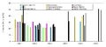 2015 discharge.png 950 × 431; 14 KB
 ADC.JPG 375 × 500; 72 KB
 ADCP.png 1,008 × 313; 38 KB
 Amoozi.jpg 375 × 500; 138 KB
 Amoozimeter.jpg 600 × 800; 125 KB
 Ant track.png 310 × 372; 183 KB
 Aquapro.JPG 299 × 448; 37 KB
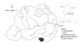
 Areal view Schaefertal.png 550 × 302; 273 KB
 Attert catchment.png 1,212 × 636; 270 KB
 Becherbach Wiki.JPG 1,018 × 609; 68 KB
 Becherbach Wiki.jpg 679 × 406; 35 KB
 Birdseye.png 709 × 471; 298 KB
 BodenPROFIL1.png 275 × 183; 112 KB
 Bot garden2.jpg 283 × 183; 49 KB
 C2.jpg 600 × 424; 145 KB
 Catchment.png 750 × 410; 193 KB
 Catchment Huewellebach.png 1,158 × 726; 561 KB
 ChickenCreek.png 300 × 195; 58 KB
 ClimateChartWeatherStationHoellensteinKraftwerk.jpg 450 × 315; 31 KB
 Climatic conditions Rio Vauz.png 459 × 404; 83 KB
 CosmicCalibration.jpg 3,072 × 1,711; 746 KB
 CosmicCalibration.pdf 0 × 0; 1.65 MB
 Cosmic ray1.JPG 500 × 281; 132 KB
 Cosmic ray2.jpg 500 × 312; 145 KB
 CrossingTresArroyos.jpg 150 × 200; 19 KB
 Davis sigma.jpg 300 × 197; 26 KB
 Dead ants.png 320 × 325; 173 KB
 Decagon 10HS.jpg 1,032 × 1,200; 268 KB
 Decagon 5 TM.jpg 200 × 200; 6 KB
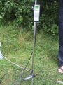
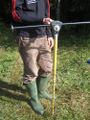 Dippingrod.JPG 375 × 500; 68 KB
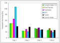 Discharge comparison.png 578 × 418; 5 KB
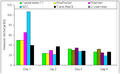 Discharge comparison 2009.png 679 × 420; 5 KB
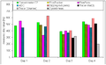 Discharge comparison 2010.png 677 × 418; 8 KB
 Dune breach.JPG 540 × 358; 140 KB
 Dyreich badenwürttemberg.GIF 800 × 920; 64 KB
 Dyrreych catchment.jpg 839 × 595; 61 KB
 EC10.jpg 185 × 190; 9 KB
 ECHOProbesSoilProfile.jpg 800 × 534; 39 KB
 ECmeter.jpg 351 × 346; 39 KB
 ECprobe.jpg 283 × 428; 49 KB
 ElectricalResisitivityProfileRepresentativeHillslope.jpg 450 × 315; 31 KB
 Example.jpg 391 × 364; 25 KB
 Flowsens.JPG 375 × 500; 72 KB
 Flowtracker.JPG 374 × 500; 69 KB
 Forest floor interception device.jpg 391 × 364; 25 KB
 GageAndLogger WithCoupler.jpg 903 × 644; 64 KB
 GageAndLogger WithoutCoupler.jpg 787 × 652; 58 KB
 Gauges of the Na Borges catchment.png 500 × 382; 218 KB
 HJ Andrews.jpg 503 × 379; 240 KB
 HM chamber.png 280 × 516; 292 KB
 HM meteorology.png 353 × 492; 217 KB
 HOAL.png 639 × 592; 292 KB
 HOBO snow.png 400 × 534; 281 KB
 HoboErrMsg1.jpg 444 × 168; 11 KB
 HoboErrMsg2.jpg 460 × 247; 17 KB
 HoellensteinHeadwaterCatchment.jpg 450 × 337; 44 KB
 Hood infiltometer.png 477 × 564; 741 KB
 Hood infiltrometer.png 434 × 383; 198 KB
 Huehnerwasser.png 200 × 175; 19 KB
 Huetelmoor Heiliger See evolution.png 850 × 296; 184 KB
 Huettelmoor view.JPG 500 × 333; 121 KB
 Hydra probe.jpg 110 × 110; 27 KB
 IMG 2598.jpg 389 × 518; 65 KB
 IMG 2603.jpg 600 × 800; 121 KB
 IMG 3959.jpg 640 × 480; 204 KB
 Image1.jpg 500 × 610; 51 KB
 Image2.gif 646 × 150; 14 KB
 KWBS - scheme2.jpg 1,690 × 1,279; 273 KB
 KWBS location3.jpg 1,444 × 1,007; 268 KB
 Klimastation Freifläche FEBRUAR97 19A.png 250 × 375; 173 KB
 Kolyma water-balance station 2016.JPG 2,816 × 2,112; 2.03 MB
 Kolyma water-balance station 2016 river valley.jpg 2,657 × 1,772; 5.62 MB
 Kolyma water-balance station 2016 rocky talus.JPG 2,657 × 1,772; 3.04 MB
 LaPueblaDeRoda.JPG 2,048 × 1,536; 279 KB
 Luxembourg int box framed.jpg 283 × 209; 40 KB
 MFT-2.JPG 500 × 375; 53 KB
 Maimai 2.png 3,587 × 1,916; 1.94 MB
 Maimai areal view.png 607 × 243; 391 KB
 Maimai stream and riparian zone.png 385 × 321; 251 KB
 Maimai throughfall trench.png 548 × 346; 401 KB
 Maimai vegetation patterns.png 640 × 480; 581 KB
 Mapkl.png 400 × 587; 276 KB
 Maxrisediagram.jpg 1,438 × 1,469; 142 KB
 Ml2x.jpg 400 × 300; 135 KB
 Ml3 deltaT.jpg 500 × 500; 15 KB
 Multiparameter ms5 ott.jpg 110 × 110; 26 KB
 NSG-Karte.jpg 738 × 724; 142 KB
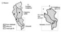
 Na Borges catchment.png 550 × 443; 222 KB
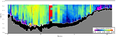
 NachHQ150 LÄNGSPROFIL98 B1 19A.png 390 × 260; 202 KB
 Net-radiometer.jpg 800 × 600; 51 KB
 Noordplas Polder.png 900 × 959; 286 KB
 Odyssey.jpg 150 × 200; 25 KB
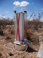
 Ombrometer.jpg 600 × 450; 27 KB
 Overland flow Weiherbach.png 335 × 216; 145 KB
 P1030849.JPG 1,920 × 2,560; 3.4 MB


