File:Wüstebach map.jpg
Jump to navigation
Jump to search
No higher resolution available.
Wüstebach_map.jpg (492 × 366 pixels, file size: 46 KB, MIME type: image/jpeg)
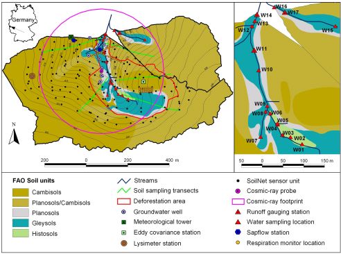
Map showing the soil types and monitoring instrumentation of the Wüstebach experiment catchment
File history
Click on a date/time to view the file as it appeared at that time.
| Date/Time | Thumbnail | Dimensions | User | Comment | |
|---|---|---|---|---|---|
| current | 12:24, 9 September 2016 | | 492 × 366 (46 KB) | Bogena (talk | contribs) | Map showing the soil types and monitoring instrumentation of the Wüstebach catchment |
| 12:20, 9 September 2016 | Error creating thumbnail: File missing | 2,691 × 2,003 (986 KB) | Bogena (talk | contribs) | Map showing the soil types and monitoring instrumentation of the Wüstebach experiment catchment |
You cannot overwrite this file.
File usage
The following page uses this file: