Difference between revisions of "HJ Andrews Experimental Forest"
Jump to navigation
Jump to search
| Line 16: | Line 16: | ||
== Measurements/Equipment == | == Measurements/Equipment == | ||
:Precipitation | :Precipitation | ||
| − | :Meteorology | + | :Meteorology CS2MET (44.12.54 N, 122.14.57 W, 485 m) since 1957 |
:Runoff | :Runoff | ||
:Soil Moisture | :Soil Moisture | ||
Revision as of 11:33, 11 November 2013
Location
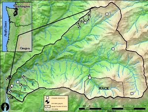
44.2 N, 122.2 W, in the central western Cascade Mountains of Oregon, USA
Catchment size
The main drainage within the HJA is Lookout Creek with 62 km²
Climate
Geology
Vegetation/Land use
Context of investigation
Measurements/Equipment
- Precipitation
- Meteorology CS2MET (44.12.54 N, 122.14.57 W, 485 m) since 1957
- Runoff
- Soil Moisture
- ET
- Sapflow
- Snow
- Catchment nutrient budgets
- Water residence time
- Sediment transport
Links to project webpages
other Links
References
- Gabrielli, C.P., McDonnell, J.J. 2012. An inexpensive and portable drill rig for bedrock groundwater studies in headwater catchments. Hydrol. Process. 26(4), 622-632, DOI: 10.1002/hyp.8212.
- Graham, C.B., McDonnell, J.J. 2010: Hillslope threshold response to rainfall: (2) Development and use of a macroscale model. Journal of Hydrology 393(1–2), 77–93, DOI: 10.1016/j.jhydrol.2010.03.008
- Graham,C:B., Barnard, H.B., Kavanagh, K.L., McNamara, J.P. 2013. Catchment scale controls the temporal connection of transpiration and diel fluctuations in stream flow. Hydrol. Process. 27(18), 2541-2556, DOI: 10.1002/hyp.9334
- Seibert, J., McDonnell, J.J. 2010. Land-cover impacts on streamflow: a change-detection modelling approach that incorporates parameter uncertainty. Hydrological Sciences Journal 55(3), 316-332, DOI: 10.1080/02626661003683264.
