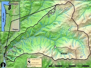
HJ Andrews Experimental Forest
Location
44.2 N, 122.2 W, in the central western Cascade Mountains of Oregon, USA, about 80 km east of Eugene.
Catchment size
The main drainage within the HJA is Lookout Creek with 62 km². Lookout Creek is a tributary to the Blue River in the MacKenzie River system. The upper portion of the watershed is divided into three major streams - Lookout Creek, Mack Creek, and McRae Creek.
Climate
Climate is Mediterranean with strong contrasts between summer and winter precipitation amounts. The catchment experiences a gradual wet-up period from about October to December and thereafter maintains very high wetness until late spring. Snow accumulations are common, but seldom persist longer than 1–2 weeks and generally melt within 1–2 days. While winters are generally wet and mild, summers are dry and rather cool. The mean annual temperature at 420 m is 8.5 °C ranging from a monthly mean of 0.6 °C in January to 17.8 °C in July. At 1,300 m the values are approximately 2 °C lower. The long-term mean annual precipitation varies from about 2300 mm (lower elevations) to 3550 mm (upper parts). Most of the precipitation (80%) falls between November and April, typically during long-duration frontal storms of low to moderate intensity.
Geology
The catchment contains residualand colluvial clay loam soils derived from andesitic tuffs (30%) and coarse breccias (70%) comprising the Little Butte Formation formed as the result of ashfall and pyroclasitic flows from Oligocene-Early Miocene volcanic activity.
Vegetation/Land use
Most of the forests are within the Tsuga heterophylla zone (sensu Franklin & Dyrness 1973) with large old-growth trees of Pseudotsuga menziesii (Mirbel) Franco., Tsuga heterophylla (Raf.) Sarg., and Thuja plicata Donn. dominating the tree layer. At higher elevations (>1,100 m), forest stands belonging to the Abies amabilis zone occur.
Context of investigation
Measurements/Equipment
- Precipitation
- Meteorology CS2MET (44.12.54 N, 122.14.57 W, 485 m) since 1957
- Runoff
- Soil Moisture
- ET
- Sapflow
- Snow
- Catchment nutrient budgets
- Water residence time
- Sediment transport
Links to project webpages
other Links
References
- Gabrielli, C.P., McDonnell, J.J. 2012. An inexpensive and portable drill rig for bedrock groundwater studies in headwater catchments. Hydrol. Process. 26(4), 622-632, DOI: 10.1002/hyp.8212.
- Graham, C.B., McDonnell, J.J. 2010: Hillslope threshold response to rainfall: (2) Development and use of a macroscale model. Journal of Hydrology 393(1–2), 77–93, DOI: 10.1016/j.jhydrol.2010.03.008
- Graham,C:B., Barnard, H.B., Kavanagh, K.L., McNamara, J.P. 2013. Catchment scale controls the temporal connection of transpiration and diel fluctuations in stream flow. Hydrol. Process. 27(18), 2541-2556, DOI: 10.1002/hyp.9334
- Griffiths, R.P., Madritch, M.D., Swanson, A.K. 2009. The effects of topography on forest soil characteristics in the Oregon Cascade Mountains (USA): Implications for the effects of climate change on soil properties. Forest Ecology and Management 257(1), 1–7, DOI: 10.1016/j.foreco.2008.08.010.
- Seibert, J., McDonnell, J.J. 2010. Land-cover impacts on streamflow: a change-detection modelling approach that incorporates parameter uncertainty. Hydrological Sciences Journal 55(3), 316-332, DOI: 10.1080/02626661003683264.
- Takahiro, S., McDonnell, J.J. 2009. A new time-space accounting scheme to predict stream water residence time and hydrograph source components at the watershed scale. WATER RESOURCES RESEARCH, 45, W07401, DOI: 10.1029/2008WR007549.
