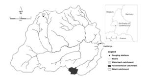
Weierbach catchment Luxembourg
Jump to navigation
Jump to search
Location
Upper Attert basin / Mosel basin, Luxembourg
Catchment size
- 0.45 km²
- 49°49’38’’N, 5°47’44’’E
Climate
- semi-oceanic
- 900 mm, 8.8 °C (2005 – 2008)
- While rainfall is distributed relatively uniform over the year without any seasonality, discharge is characterized by high flows in winter and low flows in summer
- The annual runoff ratio is approximately 55% (based on 2005–2011 streamflow data).
Geology
- Devonian slate bedrock
- Pleistocene periglacial slope deposits, which mainly consist of 2 different layers: an upper layer with a high silt content and some rock fragments, and a basal layer located immediately above the slate geological substrate dominated by rock fragments usually orientated parallel to the slopes
- soil is classified as a Dystric Endoskeletic Cambisol (Colluvic, Bathyruptic, Siltic)
Topography
- Elevation: 452 to 512 m a.s.l.
- catchment lies in the Ardennes massif, an elevated sub horizontal plateau that is cut by deep and forested V-shaped valleys
Vegetation/Land use
- mainly covered by mixed Oak-Beech hardwood deciduous forest (76% of the land cover) and conifers (24% of the land cover). A well-defined riparian zone extends up to 3 m away from the stream channel
Context of investigation
Process understanding
Measurements/Equipment
- Meteorological station since 2003
- Runoff since 2002
- Groundwater level since 2003
- Chemical analysis since2002
- Sediment
- Interception since 2003
- Geophysics
Links to project webpages
other Links
References
- Glaser, B., Klaus, J., Frei, S., Frentress, J., Pfister, L., Hopp, L., 2016. On the value of surface saturated area dynamics mapped with thermal infrared imagery for modeling the hillslope-riparian-stream continuum. Water Resour. Res., DOI: 10.1002/2015WR018414
- Jackisch, C., 2015. Linking structure and functioning of hydrological systems - How to achieve necessary experimental and model complexity with adequate effort, Dissertation, Karslruhe, Germany.
- Juilleret, J., Dondeyne, S., Vancampenhout, K., Deckers, J., Hissler, C., 2016. Mind the gap: a classification system for integrating the subsolum into soil surveys. Geoderma. http://dx.doi.org/10.1016/j.geoderma.2015.08.031.
- Juilleret, J., Iffly, J.F., Pfister, L., Hissler, C., 2011. Remarkable Pleistocene periglacial slope deposits in Luxembourg (Oesling): pedological implication and geosite potential. Bull. Soc. Nat. Luxemb. 112, 125–130.
- Loritz, R., Hassler, S.K., Jackisch, C., Allroggen, N., van Schaik, L., Wienhöfer, J., Zehe, E., 2016. Picturing and modeling catchments by representative hillslopes.Hydrol. Earth Syst. Sci., 21, 1225-1249, DOI: 10.5194/hess-21-1225-2017
- Martínez-Carreras N., Krein A., Iffly J.-F., Pfister L., Hoffmann L., Gallart F., 2007. Estimating suspended sediment loads and their uncertainty using sediment rating curves in the Attert river basin and sub-basins (Grand Duchy of Luxembourg). Proceedings of the International Conference on Off-site Impacts of Soil Erosion and Sediment Transport, Prague, Czech Republic.
- Martínez-Carreras, N., Wetzel, C.E., Frentress, J., Ector, L., McDonnell, J.J., Hoffmann, L., Pfister, L., 2015. Hydrological connectivity inferred from diatom transport through the riparian-stream system. Hydrol. Earth Syst. Sci., 19, 3133-3151, DOI: 10.5194/hess-19-3133-2015.
- Martínez‐Carreras, N., Hissler, C., Gourdol, L., Klaus, J., Juilleret, J., Iffly, J. F., Pfister, L. 2016. Storage controls on the generation of double peak hydrographs in a forested headwater catchment. J. Hydrol., 543, 255–269. doi:10.1016/j.jhydrol.2016.10.004.
- Martínez‐Carreras, N., Schwab, M., Klaus, J. Hissler, C., 2016. In situ and high frequency monitoring of suspended sediment properties using a spectrophotometric sensor. Hydrol. Process., DOI: 10.1002/hyp.10858.
- Pfister, L., Wagner, C., Vansuypeene, E., Drogue, G., Hoffmann L., 2005. Atlas climatique du grand-duchée de Luxembourg, Musée national d’histoire naturelle, Sociéetée des naturalistes luxembourgeois, 80 p., Cent. de Rech. Public-Gabriel Lippmann, Admin. des Serv. Tech. de l’Agric., Luxembourg.
- Pfister, L., Martínez-Carreras N., Hissler C., Klaus, J., Carrer G.E., Stewart M.K., McDonnell, J.J. 2017. Bedrock geology controls on catchment storage, mixing and release: a comparative analysis of 16 nested catchments. Hydrol. Process., DOI: 10.1002/hyp.11134.
- Scaini, A., Audebert, M., Hissler, C., Fenicia, F., Gourdol, L., Pfister, L., Beven, K.J., 2017. Velocity and celerity dynamics at plot scale inferred from artificial tracing experiments and time‐lapse ERT. J. Hydrol., 546, 28–43, DOI: 10.1016/j.jhydrol.2016.12.035.
- Schwab, M., Klaus, J., Pfister, L., Weiler, M. 2016. Diel discharge cycles explained through viscosity fluctuations in riparian inflow. Water Resour. Res., DOI: 10.1002/2016WR018626.
- Sprenger, M., Seeger, S., Blume, T., Weiler, M., 2016. Travel times in the vadose zone: Variability in space and time. Water Resour. Res., 52, pp. 5727—5754, DOI: http://doi.org/10.1002/2015WR018077.
- Wrede, S., Fenicia, F., Martínez-Carreras, N., Juilleret, j., Hissler, C., Krein, A., Savenije, H.H.G., Uhlenbrook, S., Kavetski, D., Pfister, L., 2015. Towards more systematic perceptual model development: a case study using 3 Luxembourgish catchments. Hydrol. Process., 29(12), 2731-2750, DOI: 10.1002/hyp.10393.
